Difference between revisions of "2018-11-04 49 8"
imported>DODO (→Tracklog) |
imported>DODO (→Photos) |
||
| Line 43: | Line 43: | ||
Image:2012-##-## ## ## Alpha.jpg | Witty Comment | Image:2012-##-## ## ## Alpha.jpg | Witty Comment | ||
--> | --> | ||
| − | <gallery perrow=" | + | <gallery perrow="4"> |
| − | + | Image:2018-11-04_49_8-5.jpg|bike (transport) | |
| − | Image:2018-11- | + | Image:2018-11-04_49_8-7.jpg|proof |
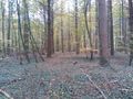
| + | Image:2018-11-04_49_8-2.jpg|west | ||
| + | Image:2018-11-04_49_8-3.jpg|Hashtree | ||
| + | Image:2018-11-04_49_8-4.jpg|north | ||
| + | Image:2018-11-04_49_8-6.jpg|east, all almost the same | ||
| + | Image:2018-11-04_49_8-1.jpg|happy hasher | ||
</gallery> | </gallery> | ||
Revision as of 14:05, 4 November 2018
| Sun 4 Nov 2018 in 49,8: 49.0542181, 8.2087338 geohashing.info google osm bing/os kml crox |
Location
In the forest south of Kandel, near the french border.
Participants
Plans
Go there by bike in the morning.
Expedition
I started at home at 10 o'clock. I rode southwards, what was nice, since we had a slight wind from the north. I rode through Römerberg, Lingenfeld, Germersheim, Sondernheim, Hördt, Rülzheim and Rheinzabern, and finally reached Kandel after one and a half hour. After Kandel I had to follow the B9, a national road that leads from the Autobahn to France and is very frequented. Luckily it was sunday today, so there were no trucks at least. It was only for 2 KM but I didn't feel well there. Then I turned left, and some minutes later I was as close to the hash as a path could lead me. I parked my bike and walked the remaining 100 m into the forest. No thicket today, so this part was easy. Five minutes later I was back at my bike and rode the remaining 6 KM to Wörth, where I took the train back home. All in all the trip took me 3 1/2 hours.
Tracklog
48 KM by bike and 41 KM by train
Photos
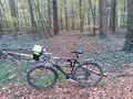
bike (transport)

proof
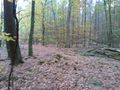
west
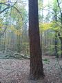
Hashtree
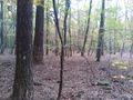
north
east, all almost the same
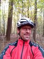
happy hasher


Achievements