Difference between revisions of "2018-11-12 47 -122"
From Geohashing
imported>Thomcat ([live picture]Towards the exit [http://www.openstreetmap.org/?lat=47.74518580&lon=-122.02768440&zoom=16&layers=B000FTF @47.7452,-122.0277]) |
imported>Thomcat ([live picture]Signpost) |
||
| Line 51: | Line 51: | ||
Image:2018-11-12_47_-122_thomcat_1542039231310.jpg|Towards the exit [http://www.openstreetmap.org/?lat=47.74518580&lon=-122.02768440&zoom=16&layers=B000FTF @47.7452,-122.0277] | Image:2018-11-12_47_-122_thomcat_1542039231310.jpg|Towards the exit [http://www.openstreetmap.org/?lat=47.74518580&lon=-122.02768440&zoom=16&layers=B000FTF @47.7452,-122.0277] | ||
| + | |||
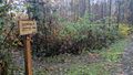
| + | Image:2018-11-12_47_-122_thomcat_1542039486694.jpg|Signpost | ||
</gallery> | </gallery> | ||
Revision as of 16:18, 12 November 2018
| Mon 12 Nov 2018 in 47,-122: 47.7452559, -122.0280863 geohashing.info google osm bing/os kml crox |
Location
Participants
Plans
Expedition
Tracklog
Photos

Geohasher @47.7450,-122.0296
Map
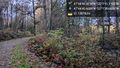
Logging road @47.7452,-122.0288
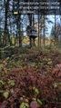
Geohash house @47.7452,-122.0282

Hash point @47.7453,-122.0281
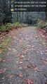
Towards the exit @47.7452,-122.0277
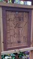
Signpost


Achievements