Difference between revisions of "2018-12-22 53 -2"
imported>Angel m |
imported>Fippe m (This page has already been categorised, so I removed category:new report.) |
||
| Line 30: | Line 30: | ||
{{#vardefine:ribbonwidth|800px}} | {{#vardefine:ribbonwidth|800px}} | ||
<!-- Add any achievement ribbons you earned below, or remove this section --> | <!-- Add any achievement ribbons you earned below, or remove this section --> | ||
| − | |||
| − | |||
| − | |||
| − | |||
| − | |||
| − | |||
[[Category:Expeditions]] | [[Category:Expeditions]] | ||
Revision as of 11:59, 25 July 2019
| Sat 22 Dec 2018 in 53,-2: 53.5865803, -2.8313590 geohashing.info google osm bing/os kml crox |
Location
A little road near Ring O'Bells
Participants
Angel and his mum.
Plans
Checked the hash, and found it's relatively close to the route we'd be driving when my mum comes to pick me up, as I'm going to stay with her for Christmas. On the way down, I asked if there's time to detour for a hash.
Expedition
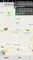
It was only a little way off our route. Mum dropped me off, and went looking for somewhere with enough space to turn the car around on the narrow lane. It didn't take long to get as close as I was going to get. The lowest distance recorded by my phone was 71 feet, as the hash itself was on the other side of a fence. Not quite close enough (I think?), but I took a panoramic photo from as close as I could get.
Photos
A little detour on the way to a family christmas week. @53.5913,-2.7404

View from the hash (73 feet) @53.5868,-2.8315
