Difference between revisions of "2008-06-03 54 -1"
From Geohashing
imported>Benjw m (remove one copy of two identical photos from gallery) |
imported>Benjw |
||
| Line 12: | Line 12: | ||
== Pictures == | == Pictures == | ||
These photos were mostly taken by [[User:Bluecont|Bluecont]]. | These photos were mostly taken by [[User:Bluecont|Bluecont]]. | ||
| − | <gallery> | + | <gallery caption="" widths="150px" heights="100px" perrow="3"> |
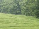
| + | Image:2008_06_03_54_-1_Field_at spot.jpg|Looking at the hedgerow where the spot was located. | ||
| + | Image:2008_06_03_54_-1_Spot_close_up.jpg|Zoomed in on where I hope the spot is. | ||
Image:2008_06_03_54_-1_Bluecont_studies_spot.jpg|Bluecont looking at the spot. | Image:2008_06_03_54_-1_Bluecont_studies_spot.jpg|Bluecont looking at the spot. | ||
| − | |||
</gallery> | </gallery> | ||
Revision as of 17:15, 11 April 2009
| Tue 3 Jun 2008 in 54,-1: 54.7427834, -1.6356494 geohashing.info google osm bing/os kml crox |
A spot between the treeline and the edge of a field on the outskirts of Brandon, County Durham.
At 1430 Bluecont and his friend David got as close to the coordinates as possible without trespassing. The location was very close to my house so we decided to visit it on a wet afternoon. Lacking in a GPS system, we located this point using a paper map.
Pictures
These photos were mostly taken by Bluecont.
- 2008 06 03 54 -1 Field at spot.jpg
Looking at the hedgerow where the spot was located.
Zoomed in on where I hope the spot is.
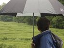
Bluecont looking at the spot.

