Difference between revisions of "2008-06-08 42 -70"
From Geohashing
imported>Cogit0 (original post) |
imported>Cogit0 m |
||
| Line 7: | Line 7: | ||
==Location== | ==Location== | ||
| − | On the western | + | On the western edge of the tip of Cape Cod, about 400m off of the shore. |
Coordinates: 42.0475817017349, -70.230915938884 | Coordinates: 42.0475817017349, -70.230915938884 | ||
| Line 23: | Line 23: | ||
<gallery caption="Cape Cod National Seashore" widths="300px" heights="200px" perrow="2"> | <gallery caption="Cape Cod National Seashore" widths="300px" heights="200px" perrow="2"> | ||
Image:Lynn_2008-06-08-1.jpg|View out towards the geohash point<br> 2008-06-08 42 -70, Provincetown, MA | Image:Lynn_2008-06-08-1.jpg|View out towards the geohash point<br> 2008-06-08 42 -70, Provincetown, MA | ||
| − | Image:Lynn_2008-06-08-2.jpg|cogit0 and civet out as far as they can | + | Image:Lynn_2008-06-08-2.jpg|[[User:cogit0|cogit0]] and civet out as far as they can bear<br> 2008-06-08 42 -70, Provincetown, MA |
</gallery> | </gallery> | ||
<BR> | <BR> | ||
Revision as of 18:16, 10 June 2008
| Sun 8 Jun 2008 in 42,-70: 42.0475817, -70.2309159 geohashing.info google osm bing/os kml crox |
Location
On the western edge of the tip of Cape Cod, about 400m off of the shore.
Coordinates: 42.0475817017349, -70.230915938884
Google maps location
xkcd map location
cogit0 and civet came close to this location, but did not reach it. The original intent was to try to swim out, but the water was far too cold for both of us. We went out as far as we could tolerate, then came back in and played on the beach.
Who Went
cogit0
civet
Pics
- Cape Cod National Seashore
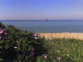
View out towards the geohash point
2008-06-08 42 -70, Provincetown, MA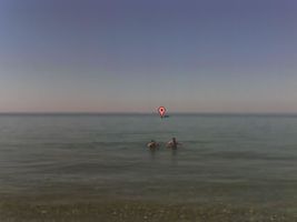
cogit0 and civet out as far as they can bear
2008-06-08 42 -70, Provincetown, MA

