Difference between revisions of "2008-06-21 -34 138"
From Geohashing
imported>Ynf (→About) |
imported>Ynf (→Photos) |
||
| Line 21: | Line 21: | ||
Image:20080621 -34 138 8.JPG|A rainbow apologized for the rain we had while at the point. | Image:20080621 -34 138 8.JPG|A rainbow apologized for the rain we had while at the point. | ||
Image:20080621 -34 138 9.JPG|GPS proof that I was nearly there. | Image:20080621 -34 138 9.JPG|GPS proof that I was nearly there. | ||
| + | Image:20080621 -34 138 D1.jpg|Geohash location on GPS map (and spots of rain!) | ||
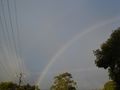
| + | Image:20080621 -34 138 D2.jpg|Another view of the rainbow (post-geohash) | ||
</gallery> | </gallery> | ||
Revision as of 03:44, 22 June 2008
| Sat 21 Jun 2008 in -34,138: -34.9793177, 138.6139621 geohashing.info google osm bing/os kml crox |
About
Thursday's geohash for northern Adelaide was in the suburb of Lower Mitcham on private property :-( so the closes i got to the point was about 31 meters.
Actually the suburb was Torrens Park (adjacent to Lower Mitcham) according to my street directory. I reckon we could have got closer, but an open house in a neighboring property was just closing as I arrived. (David)
People
Two people (around 4:00 pm) turned up
Photos
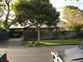
The house in which the Geo# had landed.
A rainbow apologized for the rain we had while at the point.
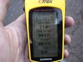
GPS proof that I was nearly there.
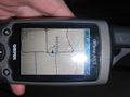
Geohash location on GPS map (and spots of rain!)
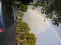
Another view of the rainbow (post-geohash)


