Difference between revisions of "2012-03-06 51 -2"
imported>Tansuo (→Plans) |
m |
||
| (8 intermediate revisions by 4 users not shown) | |||
| Line 1: | Line 1: | ||
| − | |||
<!-- If you did not specify these parameters in the template, please substitute appropriate values for IMAGE, LAT, LON, and DATE (YYYY-MM-DD format) | <!-- If you did not specify these parameters in the template, please substitute appropriate values for IMAGE, LAT, LON, and DATE (YYYY-MM-DD format) | ||
| Line 23: | Line 22: | ||
== Participants == | == Participants == | ||
<!-- who attended --> | <!-- who attended --> | ||
| − | [[tansuo]] and SR | + | [[user:tansuo|tansuo]] and SR |
== Plans == | == Plans == | ||
<!-- what were the original plans --> | <!-- what were the original plans --> | ||
| − | 1) Drive as close to location as possible, it is just off a road | + | 1) Drive as close to location as possible, it is just off a road 2) Park safely 3) Get as close as possible on foot (it is in a field) |
| − | |||
| − | 2) Park safely | ||
| − | |||
| − | 3) Get as close as possible on foot (it is in a field) | ||
Do all this sometime on the afternoon of Tuesday ... | Do all this sometime on the afternoon of Tuesday ... | ||
| Line 37: | Line 32: | ||
== Expedition == | == Expedition == | ||
<!-- how it all turned out. your narrative goes here. --> | <!-- how it all turned out. your narrative goes here. --> | ||
| + | Fairly mundane ... Parked off the road on a bare piece of ground on the verge. Walked back the way we came along the verge about 300m. SR pointed out that I was, in all likelihood, going to end-up with wet feet if I didn't watch where I was stepping. She'd spotted the reeds growing out in the verge I was too busy looking at my nuvi 550 ... | ||
| − | + | Anyway we arrived at the closet point as the hash location was in a field, just before sunset. The nuvi gave a reading of 47m from the has location. Given it was private land with a hedge and gate and all we didn't go in. Guess this was a near miss. The photo below shows the field in which the hash is located. | |
| − | |||
== Photos == | == Photos == | ||
| Line 46: | Line 41: | ||
--> | --> | ||
<gallery perrow="5"> | <gallery perrow="5"> | ||
| + | Image:2012_03_06_51_-2_TheField.jpg|A field with a geohash in it, at sunset | ||
</gallery> | </gallery> | ||
| Line 55: | Line 51: | ||
<!-- =============== USEFUL CATEGORIES FOLLOW ================ | <!-- =============== USEFUL CATEGORIES FOLLOW ================ | ||
Delete the next line ONLY if you have chosen the appropriate categories below. If you are unsure, don't worry. People will read your report and help you with the classification. --> | Delete the next line ONLY if you have chosen the appropriate categories below. If you are unsure, don't worry. People will read your report and help you with the classification. --> | ||
| − | |||
<!-- Potential categories. Please include all the ones appropriate to your expedition --> | <!-- Potential categories. Please include all the ones appropriate to your expedition --> | ||
| Line 63: | Line 58: | ||
<!-- An actual expedition: | <!-- An actual expedition: | ||
| − | |||
-- and one or more of -- | -- and one or more of -- | ||
| − | + | ||
[[Category:Expeditions with videos]] | [[Category:Expeditions with videos]] | ||
[[Category:Expedition without GPS]] | [[Category:Expedition without GPS]] | ||
--> | --> | ||
| − | + | [[Category:Expeditions]] | |
| + | [[Category:Expeditions with photos]] | ||
| + | |||
<!-- if you reached your coords: | <!-- if you reached your coords: | ||
[[Category:Coordinates reached]] | [[Category:Coordinates reached]] | ||
--> | --> | ||
| + | [[Category:Not reached - No public access]] | ||
| + | [[Category:Coordinates not reached]] | ||
<!-- or if you failed :( | <!-- or if you failed :( | ||
| Line 78: | Line 76: | ||
-- and a reason -- | -- and a reason -- | ||
[[Category:Not reached - Mother Nature]] when there is a natural obstacle between you and the target | [[Category:Not reached - Mother Nature]] when there is a natural obstacle between you and the target | ||
| − | + | when there is a man-made obstacle between you and the target | |
[[Category:Not reached - Technology]] when you failed get your GPS, car, bike or such to work | [[Category:Not reached - Technology]] when you failed get your GPS, car, bike or such to work | ||
[[Category:Not reached - Did not attempt]] when you went to an alternate location, or decided early on to abort the expedition. | [[Category:Not reached - Did not attempt]] when you went to an alternate location, or decided early on to abort the expedition. | ||
--> | --> | ||
| + | {{location|GB|ENG|GLS}} | ||
Latest revision as of 21:59, 4 March 2020
| Tue 6 Mar 2012 in 51,-2: 51.8664696, -2.1576538 geohashing.info google osm bing/os kml crox |
Location
Brockworth, Gloucester, Gloucestershire, UK
Participants
tansuo and SR
Plans
1) Drive as close to location as possible, it is just off a road 2) Park safely 3) Get as close as possible on foot (it is in a field)
Do all this sometime on the afternoon of Tuesday ...
Expedition
Fairly mundane ... Parked off the road on a bare piece of ground on the verge. Walked back the way we came along the verge about 300m. SR pointed out that I was, in all likelihood, going to end-up with wet feet if I didn't watch where I was stepping. She'd spotted the reeds growing out in the verge I was too busy looking at my nuvi 550 ...
Anyway we arrived at the closet point as the hash location was in a field, just before sunset. The nuvi gave a reading of 47m from the has location. Given it was private land with a hedge and gate and all we didn't go in. Guess this was a near miss. The photo below shows the field in which the hash is located.
Photos
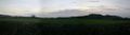
A field with a geohash in it, at sunset