Difference between revisions of "2020-04-18 40 -77"
From Geohashing
([live picture]Seen along the way [https://openstreetmap.org/?lat=40.68074650&lon=-77.92516870&zoom=16&layers=B000FTF @40.6807,-77.9252]) |
([live picture]Also seen along the way [https://openstreetmap.org/?lat=40.68080240&lon=-77.92528140&zoom=16&layers=B000FTF @40.6808,-77.9253]) |
||
| Line 44: | Line 44: | ||
Image:2020-04-18_40_-77_OfficeLinebacker_1587234513455.jpg|Seen along the way [https://openstreetmap.org/?lat=40.68074650&lon=-77.92516870&zoom=16&layers=B000FTF @40.6807,-77.9252] | Image:2020-04-18_40_-77_OfficeLinebacker_1587234513455.jpg|Seen along the way [https://openstreetmap.org/?lat=40.68074650&lon=-77.92516870&zoom=16&layers=B000FTF @40.6807,-77.9252] | ||
| + | |||
| + | Image:2020-04-18_40_-77_OfficeLinebacker_1587234535022.jpg|Also seen along the way [https://openstreetmap.org/?lat=40.68080240&lon=-77.92528140&zoom=16&layers=B000FTF @40.6808,-77.9253] | ||
</gallery> | </gallery> | ||
Revision as of 18:28, 18 April 2020
| Sat 18 Apr 2020 in 40,-77: 40.6826804, -77.9306422 geohashing.info google osm bing/os kml crox |
Location
Participants
Plans
Expedition
- Going for this one even though it's a very long hike cuz it's the weekend and I'm really been enjoying doing long distance driving lately! -- OfficeLinebacker (talk) @39.8880,-77.6710 11:09, 18 April 2020 (EDT)
Tracklog
Photos
It's all on foot from here @40.6836,-77.9140
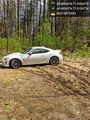
My trusty steed @40.6836,-77.9140

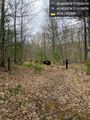
Seen along the way @40.6807,-77.9252
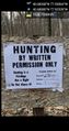
Also seen along the way @40.6808,-77.9253


Achievements