Difference between revisions of "2020-05-08 40 -78"
From Geohashing
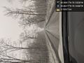
([live picture]Made it! [https://openstreetmap.org/?lat=40.90803230&lon=-78.15485390&zoom=16&layers=B000FTF @40.9080,-78.1549]) |
([live picture]Below freezing. [https://openstreetmap.org/?lat=40.90802270&lon=-78.15488480&zoom=16&layers=B000FTF @40.9080,-78.1549]) |
||
| Line 44: | Line 44: | ||
Image:2020-05-08_40_-78_OfficeLinebacker_1588979393724.jpg|Made it! [https://openstreetmap.org/?lat=40.90803230&lon=-78.15485390&zoom=16&layers=B000FTF @40.9080,-78.1549] | Image:2020-05-08_40_-78_OfficeLinebacker_1588979393724.jpg|Made it! [https://openstreetmap.org/?lat=40.90803230&lon=-78.15485390&zoom=16&layers=B000FTF @40.9080,-78.1549] | ||
| + | |||
| + | Image:2020-05-08_40_-78_OfficeLinebacker_1588979407533.jpg|Below freezing. [https://openstreetmap.org/?lat=40.90802270&lon=-78.15488480&zoom=16&layers=B000FTF @40.9080,-78.1549] | ||
</gallery> | </gallery> | ||
Revision as of 23:10, 8 May 2020
| Fri 8 May 2020 in 40,-78: 40.9081709, -78.1553777 geohashing.info google osm bing/os kml crox |
Location
Participants
Plans
Expedition
- this will be the farthest I've ever gone to reach a geocache point if I make it. On the way now, but it'll be over 3 hours of driving and who knows how long I can -- OfficeLinebacker (talk) @39.1148,-77.1918 15:40, 8 May 2020 (EDT)
- The challenge will be to see if it's the spot before nightfall, and the weather in the temperature will be a factor. It's always harder to deal with the cold when it's raining -- OfficeLinebacker (talk) @39.1208,-77.1976 15:40, 8 May 2020 (EDT)
Tracklog
Photos
Snow! @40.8628,-78.1447
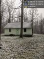
Totally unexpected house at the location. Uninhabited. @40.9080,-78.1556

Made it! @40.9080,-78.1549
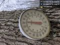
Below freezing. @40.9080,-78.1549


Achievements