Difference between revisions of "2020-01-28 -20 16"
(Adding first set of contents) |
(Add expedition narrative) |
||
| Line 15: | Line 15: | ||
== Expedition == | == Expedition == | ||
| − | + | ||
| + | Lia and [[User:Pah|pah]] [[File:U+110DB.png|middle|6px|link=User:Pah]] went on a three weeks and ~4000km road trip through Namibia in January and found little opportunities (mostly due to lack of network connectivity) to explore any hashing opportunities. On their way back from the [[wikipedia:Etosha National Park|Etosha National Park]], they found today’s hash point promisingly close to their route on the B1 national road. | ||
| + | |||
| + | When they first left the B1 as per the suggestion from Google, they drove around 6km on a sand road between farming fences and then realized, that this road won’t bring them closer to the hash. So they decided to head back to the main road and look for another entry. Soon they found a service path next to railroad tracks going parallel to the B1 (but still ~200m closer towards the hash). As they continued on this path, they made it as close as 3.2km to the hash, but then only saw fences as far as theIr eyes could see. | ||
| + | |||
| + | A few hundred meters further, they reached a locked gate and accepted, that they won’t reach the hashpoint today and [[User:Pah|pah]] [[File:U+110DB.png|middle|6px|link=User:Pah]] missed another opportunity towards reaching the [[Globetrotters Geohash]] after the previous thwarted attempts on [[2016-05-21 23 -82|2016-05-21]] and [[2019-01-19 -12 -77|2019-01-19]]. | ||
== Photos == | == Photos == | ||
<gallery perrow="5"> | <gallery perrow="5"> | ||
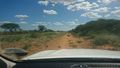
Image:2020-01-28 -20 16 pah 001.png | Not getting closer from here... | Image:2020-01-28 -20 16 pah 001.png | Not getting closer from here... | ||
| − | Image:2020-01-28 -20 16 pah 002.jpg | Turning around | + | Image:2020-01-28 -20 16 pah 002.jpg | Turning around (spot the butterfly...) |
Image:2020-01-28 -20 16 pah 003.jpg | Back on B1 | Image:2020-01-28 -20 16 pah 003.jpg | Back on B1 | ||
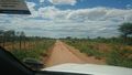
Image:2020-01-28 -20 16 pah 004.jpg | On a service “road” next to rail tracks | Image:2020-01-28 -20 16 pah 004.jpg | On a service “road” next to rail tracks | ||
Image:2020-01-28 -20 16 pah 005.png | As close as we got #1 | Image:2020-01-28 -20 16 pah 005.png | As close as we got #1 | ||
| − | Image:2020-01-28 -20 16 pah 006.png | As close as we got # | + | Image:2020-01-28 -20 16 pah 006.png | As close as we got #2 |
Image:2020-01-28 -20 16 pah 007.jpg | View in the direction of the hash | Image:2020-01-28 -20 16 pah 007.jpg | View in the direction of the hash | ||
Image:2020-01-28 -20 16 pah 008.jpg | Fence ... | Image:2020-01-28 -20 16 pah 008.jpg | Fence ... | ||
| Line 71: | Line 76: | ||
| name = [[User:Pah|pah]] [[File:U+110DB.png|middle|6px|link=User:Pah]] | | name = [[User:Pah|pah]] [[File:U+110DB.png|middle|6px|link=User:Pah]] | ||
}} | }} | ||
| − | |||
| − | |||
| − | |||
[[Category:Expeditions]] | [[Category:Expeditions]] | ||
[[Category:Expeditions with photos]] | [[Category:Expeditions with photos]] | ||
| − | |||
[[Category:Coordinates not reached]] | [[Category:Coordinates not reached]] | ||
[[Category:Not reached - No public access]] | [[Category:Not reached - No public access]] | ||
Revision as of 19:53, 12 July 2020

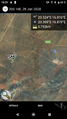
| Tue 28 Jan 2020 in -20,16: -20.3239418, 16.8159630 geohashing.info google osm bing/os kml crox |
Location
On farmland about half-way between Okaputo and Otjiwarongo, close to B1.
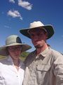
Participants
Expedition
Lia and pah ![]() went on a three weeks and ~4000km road trip through Namibia in January and found little opportunities (mostly due to lack of network connectivity) to explore any hashing opportunities. On their way back from the Etosha National Park, they found today’s hash point promisingly close to their route on the B1 national road.
went on a three weeks and ~4000km road trip through Namibia in January and found little opportunities (mostly due to lack of network connectivity) to explore any hashing opportunities. On their way back from the Etosha National Park, they found today’s hash point promisingly close to their route on the B1 national road.
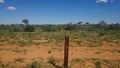
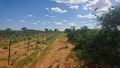
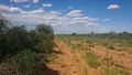
When they first left the B1 as per the suggestion from Google, they drove around 6km on a sand road between farming fences and then realized, that this road won’t bring them closer to the hash. So they decided to head back to the main road and look for another entry. Soon they found a service path next to railroad tracks going parallel to the B1 (but still ~200m closer towards the hash). As they continued on this path, they made it as close as 3.2km to the hash, but then only saw fences as far as theIr eyes could see.
A few hundred meters further, they reached a locked gate and accepted, that they won’t reach the hashpoint today and pah ![]() missed another opportunity towards reaching the Globetrotters Geohash after the previous thwarted attempts on 2016-05-21 and 2019-01-19.
missed another opportunity towards reaching the Globetrotters Geohash after the previous thwarted attempts on 2016-05-21 and 2019-01-19.
Photos
Not getting closer from here...
Turning around (spot the butterfly...)
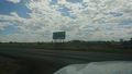
Back on B1
On a service “road” next to rail tracks
As close as we got #1

As close as we got #2
View in the direction of the hash
Fence ...
... more fence
Frowns
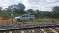
View across the tracks to our hash mobile
Closed gate


Achievements

pah
|
pah
|
pah
|