Difference between revisions of "2010-09-13 53 10"
imported>Pne (start) |
m |
||
| (7 intermediate revisions by 2 users not shown) | |||
| Line 1: | Line 1: | ||
| − | |||
| − | |||
| − | |||
| − | |||
| − | |||
| − | |||
| − | |||
| − | |||
| − | |||
| − | |||
{{meetup graticule | {{meetup graticule | ||
| lat=53 | | lat=53 | ||
| lon=10 | | lon=10 | ||
| date=2010-09-13 | | date=2010-09-13 | ||
| + | | graticule_name=Hamburg (East), Germany | ||
| + | | graticule_link=Hamburg (East), Germany | ||
}} | }} | ||
| Line 18: | Line 10: | ||
__NOTOC__ | __NOTOC__ | ||
== Location == | == Location == | ||
| − | + | In a field just outside the city limits of Hamburg. It was a part of Lower Saxony that jutted into a bit of Hamburg there, near the quarter "Groß Moor". | |
== Participants == | == Participants == | ||
| − | + | * [[User:Pne|Pne]] | |
== Plans == | == Plans == | ||
| − | + | Cycle there after work. I wanted to go cross-country from Kanzlerhofweg on the west, but a check of Google Maps's satellite view showed what seemed to be rivers crossing the field there, so I decided to start from the path at the south instead. | |
== Expedition == | == Expedition == | ||
| − | + | Cycled along the path until I was roughly abreast of the hashpoint. There were indeed quite a few watercourses - presumably drainage canals. There also seemed to be small canals between the various fields. Some of the fields had cows on them. | |
| + | |||
| + | I finally came to what I hoped was the right field and started out. I could see why the neighbouring part of Hamburg is called Groß Moor (Great Moor) - the land was a bit boggy, and whenever it dipped a bit one could see water. | ||
| + | |||
| + | I headed straight for the mark on my satnav, and got closer and closer to the fence dividing "my" field from the next one, which had cows on it. There was also a ditch in front of the fence. | ||
| + | |||
| + | The closer I got to the hashpoint, the more I feared that it would not be in "my" field after all, but in the cows' field, and that ended up being the case. | ||
| + | |||
| + | Still, I got within about 50 m of the hashpoint, and didn't feel like backtracking all the way to the path, then all the way back in the cow field (nor did I fancy jumping over the ditch and climbing over the barbed-wire fence). I also wasn't sure what the cows would think of me. They certainly seemed curious enough - the closer I got the fence, the more cows started coming towards me. | ||
| + | |||
| + | I got as close as I could, took a couple of pictures, and started back. Not quite the same way I had come, and I ended up getting my feet a bit wet. Ah well. | ||
| + | |||
| + | And the ride uphill to my home from there was unexpectedly hard; I'm glad my regular route to and from work doesn't go that way. | ||
== Tracklog == | == Tracklog == | ||
| − | + | *http://pne.mizinamo.org/geohashing/Tracklog_2010-09-13_53_10.gpx | |
== Photos == | == Photos == | ||
| Line 37: | Line 41: | ||
--> | --> | ||
<gallery perrow="5"> | <gallery perrow="5"> | ||
| + | Image:2010-09-13 53 10 helmet.JPG | The intrepid geohasher with a stupid grin | ||
| + | Image:2010-09-13 53 10 bicycle.JPG | My trusty vehicle | ||
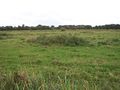
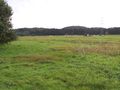
| + | Image:2010-09-13 53 10 field.JPG | The field I was about to enter - sadly, not the one with the hashpoint! | ||
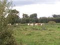
| + | Image:2010-09-13 53 10 cows other field.JPG | Bovine neighbours on the correct field | ||
| + | Image:2010-09-13 53 10 geohash.JPG | The geohash point is probably in this shot somewhere | ||
| + | Image:2010-09-13 53 10 satnav.JPG | My co-ordinates at the closest point I reached to the hashpoint | ||
| + | Image:2010-09-13 53 10 distance.JPG | I got fairly close - but no cigar! Maybe 50m away. | ||
| + | Image:2010-09-13 53 10 cows 2.JPG | The cows looking at me from the other side of the fence. | ||
| + | Image:2010-09-13 53 10 looking back.JPG | The field I had crossed | ||
| + | Image:2010-09-13 53 10 ditch and fence.JPG | Ditch (with plants in and around it) and fence separating me from the field with the hashpoint | ||
</gallery> | </gallery> | ||
| + | |||
| + | == Videos == | ||
| + | * http://www.youtube.com/watch?v=3NiPVAnDROg | ||
== Achievements == | == Achievements == | ||
| Line 43: | Line 60: | ||
<!-- Add any achievement ribbons you earned below, or remove this section --> | <!-- Add any achievement ribbons you earned below, or remove this section --> | ||
| − | |||
| − | |||
| − | |||
| − | |||
| − | |||
| − | |||
| − | |||
| − | |||
| − | |||
| − | |||
| − | |||
[[Category:Expeditions]] | [[Category:Expeditions]] | ||
| − | |||
[[Category:Expeditions with photos]] | [[Category:Expeditions with photos]] | ||
[[Category:Expeditions with videos]] | [[Category:Expeditions with videos]] | ||
| − | |||
| − | |||
| − | |||
| − | |||
| − | |||
| − | |||
| − | |||
| − | |||
[[Category:Coordinates not reached]] | [[Category:Coordinates not reached]] | ||
| − | |||
| − | |||
[[Category:Not reached - No public access]] | [[Category:Not reached - No public access]] | ||
| − | + | {{location|DE|NI|WL}} | |
| − | |||
| − | |||
Latest revision as of 21:08, 26 January 2021
| Mon 13 Sep 2010 in Hamburg (East), Germany: 53.4423061, 10.0250776 geohashing.info google osm bing/os kml crox |
Location
In a field just outside the city limits of Hamburg. It was a part of Lower Saxony that jutted into a bit of Hamburg there, near the quarter "Groß Moor".
Participants
Plans
Cycle there after work. I wanted to go cross-country from Kanzlerhofweg on the west, but a check of Google Maps's satellite view showed what seemed to be rivers crossing the field there, so I decided to start from the path at the south instead.
Expedition
Cycled along the path until I was roughly abreast of the hashpoint. There were indeed quite a few watercourses - presumably drainage canals. There also seemed to be small canals between the various fields. Some of the fields had cows on them.
I finally came to what I hoped was the right field and started out. I could see why the neighbouring part of Hamburg is called Groß Moor (Great Moor) - the land was a bit boggy, and whenever it dipped a bit one could see water.
I headed straight for the mark on my satnav, and got closer and closer to the fence dividing "my" field from the next one, which had cows on it. There was also a ditch in front of the fence.
The closer I got to the hashpoint, the more I feared that it would not be in "my" field after all, but in the cows' field, and that ended up being the case.
Still, I got within about 50 m of the hashpoint, and didn't feel like backtracking all the way to the path, then all the way back in the cow field (nor did I fancy jumping over the ditch and climbing over the barbed-wire fence). I also wasn't sure what the cows would think of me. They certainly seemed curious enough - the closer I got the fence, the more cows started coming towards me.
I got as close as I could, took a couple of pictures, and started back. Not quite the same way I had come, and I ended up getting my feet a bit wet. Ah well.
And the ride uphill to my home from there was unexpectedly hard; I'm glad my regular route to and from work doesn't go that way.
Tracklog
Photos
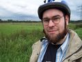
The intrepid geohasher with a stupid grin
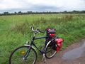
My trusty vehicle
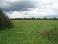
The field I was about to enter - sadly, not the one with the hashpoint!
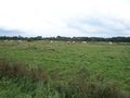
Bovine neighbours on the correct field
The geohash point is probably in this shot somewhere
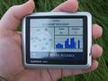
My co-ordinates at the closest point I reached to the hashpoint
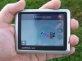
I got fairly close - but no cigar! Maybe 50m away.
The cows looking at me from the other side of the fence.
The field I had crossed
Ditch (with plants in and around it) and fence separating me from the field with the hashpoint


