Difference between revisions of "2013-09-01 36 -79"
imported>Davedrowsy (→Participants) |
m |
||
| (18 intermediate revisions by 3 users not shown) | |||
| Line 1: | Line 1: | ||
| − | |||
| − | |||
| − | |||
| − | |||
| − | |||
| − | |||
| − | |||
| − | |||
| − | |||
| − | |||
{{meetup graticule | {{meetup graticule | ||
| lat=36 | | lat=36 | ||
| Line 24: | Line 14: | ||
<!-- who attended: If you link to your wiki user name in this section, your expedition will be picked up by the various statistics generated for geohashing. You may use three tildes ~ as a shortcut to automatically insert the user signature of the account you are editing with. | <!-- who attended: If you link to your wiki user name in this section, your expedition will be picked up by the various statistics generated for geohashing. You may use three tildes ~ as a shortcut to automatically insert the user signature of the account you are editing with. | ||
--> | --> | ||
| − | [[User: | + | [[User:Dave Drowsy|Dave Drowsy]], |
| + | |||
| + | his wife, Renay, and | ||
| + | |||
| + | their greyhound, Barbara | ||
== Plans == | == Plans == | ||
<!-- what were the original plans --> | <!-- what were the original plans --> | ||
| + | Living near the corner of four graticules, we had our pick of four hash points for this, our very first geohashing expedition! We opted for this one because it was the closest, and we wanted to check out the pond. Our drive will also take us through downtown Mebane, which might be kinda cool. The plan is to drive to the elementary school across the street and park there, then take a short walk across the street and past what appears to be a small house, through the field and up to the pond where the hash point lies. We decided to take Barbara with us, since it's nice out and it won't be too far of a walk. | ||
== Expedition == | == Expedition == | ||
<!-- how it all turned out. your narrative goes here. --> | <!-- how it all turned out. your narrative goes here. --> | ||
| + | We parked at the elementary school and took a goofy picture of Barb and I in front of the sign, then set out on foot to find the hash point, which turned out to be on private property. We got a little nervous as we passed the Community Watch sign in front of the house, but decided to press on anyways, figuring we'd be ready to scram at a moment's notice if anyone came out and asked us to leave. We walked along the outskirts of the field and followed the GPS trail into the woods. Alas, we never made it to the pond, as we ran into a small barbed wire fence soon after entering the woods. Drats! We were about .002 degrees of latitude away, too! If we didn't have Barbara with us, we might have gotten over the fence... oh well. At least we tried! | ||
| − | + | While we were in Burlington, we made a detour to the downtown area to get Barbara some water and ourselves some lunch at the Burlington Food Co-Op. All in all, a fun Sunday afternoon, even if we didn't make it to the hash point. I guess you can't win 'em all. | |
| − | |||
== Photos == | == Photos == | ||
| Line 40: | Line 35: | ||
--> | --> | ||
<gallery perrow="5"> | <gallery perrow="5"> | ||
| + | Image:2013-09-01-school-1.jpg | Two cheesy grins | ||
| + | Image:2013-09-01-school-2.jpg | ||
| + | Image:2013-09-01-field.jpg | ||
| + | Image:2013-09-01-woods-1.jpg | ||
| + | Image:2013-09-01-barn.jpg | ||
| + | Image:2013-09-01-fence.jpg | D'oh!! | ||
| + | Image:2013-09-01-woods-2.jpg | Back out of the woods... | ||
</gallery> | </gallery> | ||
| − | == | + | == Consolation Prize == |
| − | {{ | + | {{No trespassing | latitude = 36 | longitude = -79 | date = 2013-09-01 | name = Dave Drowsy | distance = }} |
| − | |||
| − | |||
| − | |||
| − | |||
| − | |||
| − | |||
| − | |||
| − | |||
| − | |||
| − | |||
| − | |||
| − | |||
[[Category:Expeditions]] | [[Category:Expeditions]] | ||
| − | |||
[[Category:Expeditions with photos]] | [[Category:Expeditions with photos]] | ||
| − | |||
| − | |||
| − | |||
| − | |||
| − | |||
| − | |||
| − | |||
| − | |||
| − | |||
[[Category:Coordinates not reached]] | [[Category:Coordinates not reached]] | ||
| − | |||
| − | |||
| − | |||
| − | |||
| − | |||
[[Category:Not reached - No public access]] | [[Category:Not reached - No public access]] | ||
| − | + | {{location|US|NC|AA}} | |
| − | |||
| − | |||
| − | |||
| − | |||
| − | |||
| − | |||
| − | |||
Latest revision as of 18:02, 27 August 2021
| Sun 1 Sep 2013 in 36,-79: 36.2189827, -79.3094025 geohashing.info google osm bing/os kml crox |
Location
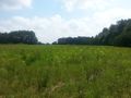
In a field right by what appears to be a pond, across the street from Pleasant Grove Elementary School in Burlington.
Participants
his wife, Renay, and
their greyhound, Barbara
Plans
Living near the corner of four graticules, we had our pick of four hash points for this, our very first geohashing expedition! We opted for this one because it was the closest, and we wanted to check out the pond. Our drive will also take us through downtown Mebane, which might be kinda cool. The plan is to drive to the elementary school across the street and park there, then take a short walk across the street and past what appears to be a small house, through the field and up to the pond where the hash point lies. We decided to take Barbara with us, since it's nice out and it won't be too far of a walk.
Expedition
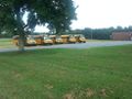
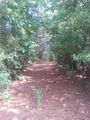
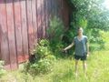
We parked at the elementary school and took a goofy picture of Barb and I in front of the sign, then set out on foot to find the hash point, which turned out to be on private property. We got a little nervous as we passed the Community Watch sign in front of the house, but decided to press on anyways, figuring we'd be ready to scram at a moment's notice if anyone came out and asked us to leave. We walked along the outskirts of the field and followed the GPS trail into the woods. Alas, we never made it to the pond, as we ran into a small barbed wire fence soon after entering the woods. Drats! We were about .002 degrees of latitude away, too! If we didn't have Barbara with us, we might have gotten over the fence... oh well. At least we tried!
While we were in Burlington, we made a detour to the downtown area to get Barbara some water and ourselves some lunch at the Burlington Food Co-Op. All in all, a fun Sunday afternoon, even if we didn't make it to the hash point. I guess you can't win 'em all.
Photos
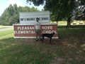
Two cheesy grins
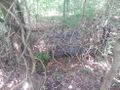
D'oh!!
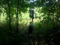
Back out of the woods...


Consolation Prize
Dave Drowsy earned the No trespassing consolation prize
|