Difference between revisions of "2008-07-03 40 -105"
imported>Sethant (add map) |
imported>Sethant (formatting) |
||
| Line 1: | Line 1: | ||
| + | __NOTOC__ | ||
{{meetup graticule | {{meetup graticule | ||
| − | | map=<map lat="40" lon="-105" date="2008-07- | + | | map=<map lat="40" lon="-105" date="2008-07-03" /> |
| lat=40 | | lat=40 | ||
| lon=-105 | | lon=-105 | ||
| date=2008-07-03 | | date=2008-07-03 | ||
}} | }} | ||
| − | |||
| − | |||
| − | |||
The NW [[Denver, Colorado|Denver]] geohash for 3 July 2008 was located in the southeast corner of an agricultural field between Fort Collins and Wellington, Colorado, about half a mile west of Interstate 25 and almost directly adjacent to BNSF railroad tracks. | The NW [[Denver, Colorado|Denver]] geohash for 3 July 2008 was located in the southeast corner of an agricultural field between Fort Collins and Wellington, Colorado, about half a mile west of Interstate 25 and almost directly adjacent to BNSF railroad tracks. | ||
| Line 13: | Line 11: | ||
Not wanting to disturb local farmers (who were driving past slowly in pickup trucks with quizzical expressions) or get my shoes wet, or trespass onto private land, I took a picture at the edge of the field and enjoyed playing with a slinky for a few moments before proceeding home at about 4:15 p.m. My bicycle may or may not have broken a spoke on the return journey. | Not wanting to disturb local farmers (who were driving past slowly in pickup trucks with quizzical expressions) or get my shoes wet, or trespass onto private land, I took a picture at the edge of the field and enjoyed playing with a slinky for a few moments before proceeding home at about 4:15 p.m. My bicycle may or may not have broken a spoke on the return journey. | ||
| + | |||
| + | ==Participants== | ||
| + | |||
| + | Sadly, just me, unless others showed up later. -- [[User:Sethant|Sethant]] 01:24, 4 July 2008 (UTC) | ||
| + | |||
| + | ==Achievements== | ||
| + | <gallery widths="100px" align=center> | ||
| + | Image:Landgeohash.png|[[Land Geohash]] | ||
| + | Image:Bikegeohashing.png|[[Bicycle Geohash]] | ||
| + | </gallery> | ||
==Pictures== | ==Pictures== | ||
| Line 19: | Line 27: | ||
Image:Seth-at-40N-105W-2008-07-03.jpg|As close as I could get to the site itself. | Image:Seth-at-40N-105W-2008-07-03.jpg|As close as I could get to the site itself. | ||
Image:2008-07-03_40_-105_Pic_1.JPG|Looking NW from the corner of the field. The arrow marks the likely geohash site within the field | Image:2008-07-03_40_-105_Pic_1.JPG|Looking NW from the corner of the field. The arrow marks the likely geohash site within the field | ||
| − | Image:2008-07-03_40_-105_Pic_2.JPG|Looking S. Note the "old" and "new W" along the railroad tracks; the Budweiser plant sits in the background. | + | Image:2008-07-03_40_-105_Pic_2.JPG|Looking S. Note the "old W" and "new W" along the railroad tracks; the Budweiser plant sits in the background. |
Image:2008-07-03_40_-105_Pic_3.JPG|Looking NE across more fields. Traffic on I-25 is just barely visible in the upper left. | Image:2008-07-03_40_-105_Pic_3.JPG|Looking NE across more fields. Traffic on I-25 is just barely visible in the upper left. | ||
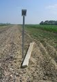
Image:2008-07-03_40_-105_Pic_4.JPG|Intersection of Giddings Rd. (NS) and Douglas Rd. (ER), the closest major crossroads to the site | Image:2008-07-03_40_-105_Pic_4.JPG|Intersection of Giddings Rd. (NS) and Douglas Rd. (ER), the closest major crossroads to the site | ||
| Line 26: | Line 34: | ||
[[Category:Meetup on 2008-07-03]] | [[Category:Meetup on 2008-07-03]] | ||
| + | [[Category:Expeditions with photos]] | ||
Revision as of 01:24, 4 July 2008
| Thu 3 Jul 2008 in 40,-105: 40.6436863, -105.0108034 geohashing.info google osm bing/os kml crox |
The NW Denver geohash for 3 July 2008 was located in the southeast corner of an agricultural field between Fort Collins and Wellington, Colorado, about half a mile west of Interstate 25 and almost directly adjacent to BNSF railroad tracks.
I biked from Fort Collins (the bike lanes on the roads are quite good leading out to the Budweiser plant, which is about two miles south of today's location), about 10 miles in total. The directions for this week did indeed include "turn off the paved road." Parking my bike at the RR crossing, it was about a third of a mile walk north to the corner of the field. The actual coordinates, based on the satellite imagery, appear to be about 20 feet into the field, which was partially plowed and marshy.
Not wanting to disturb local farmers (who were driving past slowly in pickup trucks with quizzical expressions) or get my shoes wet, or trespass onto private land, I took a picture at the edge of the field and enjoyed playing with a slinky for a few moments before proceeding home at about 4:15 p.m. My bicycle may or may not have broken a spoke on the return journey.
Participants
Sadly, just me, unless others showed up later. -- Sethant 01:24, 4 July 2008 (UTC)
Achievements


Pictures
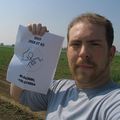
As close as I could get to the site itself.
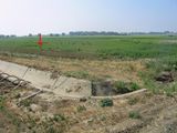
Looking NW from the corner of the field. The arrow marks the likely geohash site within the field
Looking S. Note the "old W" and "new W" along the railroad tracks; the Budweiser plant sits in the background.
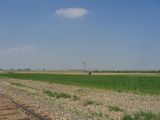
Looking NE across more fields. Traffic on I-25 is just barely visible in the upper left.
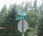
Intersection of Giddings Rd. (NS) and Douglas Rd. (ER), the closest major crossroads to the site
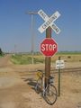
The intrepid bicycle, parked at the intersection of Giddings (the dirt road) and the RR tracks.


