Difference between revisions of "2021-10-23 -38 146"
From Geohashing
(→Expedition) |
(→Photos) |
||
| Line 34: | Line 34: | ||
== Tracklog == | == Tracklog == | ||
<!-- if your GPS device keeps a log, you may use Template:Tracklog, post a link here, or both --> | <!-- if your GPS device keeps a log, you may use Template:Tracklog, post a link here, or both --> | ||
| + | |||
== Photos == | == Photos == | ||
| Line 39: | Line 40: | ||
Image:2020-##-## ## ## Alpha.jpg | Witty Comment | Image:2020-##-## ## ## Alpha.jpg | Witty Comment | ||
--> | --> | ||
| − | <gallery | + | <gallery> |
| + | File:Geohash 2020-10-23 138 -46 5.jpg|At the hash | ||
| + | File:Geohash 2020-10-23 138 -46 6.png|Proof! | ||
| + | File:Geohash 2020-10-23 138 -46 1.jpg|Pine forest | ||
| + | File:Geohash 2020-10-23 138 -46 2.jpg|Car graveyard | ||
| + | File:Geohash 2020-10-23 138 -46 3.jpg|Mud mud mud | ||
| + | File:Geohash 2020-10-23 138 -46 4.jpg|Emerging to the cleared area | ||
</gallery> | </gallery> | ||
Revision as of 11:35, 9 November 2021
| Sat 23 Oct 2021 in -38,146: -38.2063380, 146.2300434 geohashing.info google osm bing/os kml crox |
Location
By a creek in a pine forest.
Participants
Plans
Expedition
Thought this one would be better with my mountain bike. I was not wrong. Rain had eased, but the mud remained, necessitating several stints of hike-a-bike even with my mountain bike.
I was fearing a bit of troublesome bush-bashing to get to the hash, which was several metres off the path, but luckily the bush had thinned out enough that it was a simple matter to scramble down the embankment and find the coordinates.
Tracklog
Photos
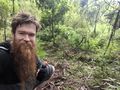
At the hash

Proof!
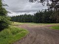
Pine forest
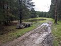
Car graveyard
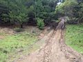
Mud mud mud
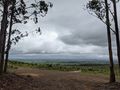
Emerging to the cleared area


Achievements