Difference between revisions of "2022-03-06 -37 143"
| Line 1: | Line 1: | ||
<!-- If you did not specify these parameters in the template, please substitute appropriate values for IMAGE, LAT, LON, and DATE (YYYY-MM-DD format) | <!-- If you did not specify these parameters in the template, please substitute appropriate values for IMAGE, LAT, LON, and DATE (YYYY-MM-DD format) | ||
| − | |||
| − | |||
Remove this section if you don't want an image at the top (left) of your report. You should remove the "Image:" or "File:" | Remove this section if you don't want an image at the top (left) of your report. You should remove the "Image:" or "File:" | ||
| Line 12: | Line 10: | ||
| date={{#explode:{{SUBPAGENAME}}| |0}} | | date={{#explode:{{SUBPAGENAME}}| |0}} | ||
}}<!-- edit as necessary --> | }}<!-- edit as necessary --> | ||
| + | |||
| + | |||
| + | |||
__NOTOC__ | __NOTOC__ | ||
== Location == | == Location == | ||
| Line 17: | Line 18: | ||
== Participants == | == Participants == | ||
| + | |||
*[[User:Stevage|Stevage]] | *[[User:Stevage|Stevage]] | ||
*EB | *EB | ||
*KP | *KP | ||
| − | |||
== Expedition == | == Expedition == | ||
| + | [[File:PXL_20220306_054023505.jpg|400px|thumb|left]] | ||
The three of us were driving back from a hiking trip around Mt Buangor. I'd seen the geohash location, and was a bit undecided. On the one hand, it looked pretty dubious: 870m from the road inside a farm, further than I really want to go. On the other, it was such a short detour, it seemed silly not to at least check it out. | The three of us were driving back from a hiking trip around Mt Buangor. I'd seen the geohash location, and was a bit undecided. On the one hand, it looked pretty dubious: 870m from the road inside a farm, further than I really want to go. On the other, it was such a short detour, it seemed silly not to at least check it out. | ||
| Line 38: | Line 40: | ||
Image:2020-##-## ## ## Alpha.jpg | Witty Comment | Image:2020-##-## ## ## Alpha.jpg | Witty Comment | ||
--> | --> | ||
| − | <gallery | + | <gallery> |
| + | File:PXL_20220306_054023505.jpg | ||
| + | File:PXL_20220306_054106007.jpg | ||
</gallery> | </gallery> | ||
Revision as of 23:04, 6 March 2022
| Sun 6 Mar 2022 in -37,143: -37.4424864, 143.6064815 geohashing.info google osm bing/os kml crox |
Location
In a farm, not far from Beaufort.
Participants
- Stevage
- EB
- KP
Expedition
The three of us were driving back from a hiking trip around Mt Buangor. I'd seen the geohash location, and was a bit undecided. On the one hand, it looked pretty dubious: 870m from the road inside a farm, further than I really want to go. On the other, it was such a short detour, it seemed silly not to at least check it out.
After a quick bakery stop in Beaufort, we headed off. The road was nice and quiet, uneventful other than a few big clumps of hay apparently fallen off the back of a truck. "HAY!" I yelled. No one laughed.
There was a great view of wind turbines on the hills.
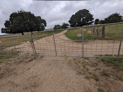
We stopped, got out, had a look at the approach. There was a gate, not locked, but not inviting either.
There was nothing exactly stopping me going in, but I didn't particularly feel like an awkward conversation with a farmer, and there was nothing particularly enticing about the spot.
We got back in the car and vroomed off.


