Difference between revisions of "2013-01-10 30 -93"
imported>Loganrah (→Location) |
m |
||
| (26 intermediate revisions by 4 users not shown) | |||
| Line 1: | Line 1: | ||
| − | |||
| − | |||
| − | |||
| − | |||
| − | |||
| − | |||
| − | |||
| − | |||
| − | |||
{{meetup graticule | {{meetup graticule | ||
| lat=30 | | lat=30 | ||
| lon=-93 | | lon=-93 | ||
| − | | date= | + | | date=2013-01-10 |
}} | }} | ||
| − | |||
__NOTOC__ | __NOTOC__ | ||
| + | |||
== Location == | == Location == | ||
| − | + | Hash co-ordinates given by the small hash inquiry tool as 30.100240 North, 93.958631 West. Just slightly off a set of accesible train tracks near Vidor, Texas. | |
| − | Hash co-ordinates given by the small hash inquiry tool as 30.100240 North, 93.958631 West. | + | |
| − | Started the expedition in Sam Houston Jones State Park, just outside Lake Charles, Louisiana. | + | Started the expedition in Sam Houston Jones State Park, just outside Lake Charles, Louisiana. |
| − | While we did not complete the Hash exactly we got pretty close | + | |
| + | While we did not complete the Hash exactly we got pretty close at 30.10073 North, 93.96047 West, within sight of the geohash. | ||
== Participants == | == Participants == | ||
| − | |||
| − | |||
| − | + | * [[User:Loganrah|Toby]] | |
| − | + | * Carmel | |
== Expedition == | == Expedition == | ||
| − | + | I've been wanting to hash for a while but in my home area (Sydney, Australia) the hash is usually in the water, | |
| + | inaccessible bush or private property. At the moment me and my fellow geohasher Carmel are traveling cross country | ||
| + | in a campervan from New York to Los Angeles and I was pretty excited when I checked the hash and saw that it | ||
| + | was only about 10 miles off our planned route to Houston Texas for the day, so we decided to give it a go. | ||
| + | |||
| + | After leaving the lovely surrounds of Sam Houston Jones state park and crossing the border into Texas we turned off the I-10 and followed our GPS down through some pretty farm land towards the hash. Things started to go a little sour as we approached the hash though, I'd checked beforehand and seen that the hash was located just off a set of railway tracks that looked like we should be able to walk down them. Unfortunately as we got closer to the hash the surroundings turned from nice looking farmland to some pretty run down houses, a lot of stray dogs and more trash on the side of the road than you could poke a stick at (including the bellow pictured fish heads, which were right near the hash with two empty cases of beer and plenty of other rubbish). When we arrived at the closest point on the road to the hash at the railway crossing we felt a bit nervous about getting out and walking down the tracks since it definitely seemed like we were in the kind of place where people might not take well to that so we settled for taking a photo of the hash point and hurrying on our way. | ||
| − | + | I'm not counting this as a completed hash though I will definitely award my self the Chickened Out ribbon | |
| − | + | since that's exactly what happened. | |
== Photos == | == Photos == | ||
| − | |||
| − | |||
| − | |||
<gallery perrow="5"> | <gallery perrow="5"> | ||
| + | image:20130110 30 -93 6.jpg| Breakfast of champions (or chickens) at the start of the hash with Carmel. | ||
| + | image:20130110 30 -93 5.jpg|Our ride/Home for the hash and our road trip | ||
| + | image:20130110 30 -93 4.jpg|The van through the lone star at the Texas border. | ||
| + | image:20130110 30 -93 3.jpg|Welcome to Texas | ||
| + | image:20130110 2.jpg|Toby with the hash point just down the tracks in the background. | ||
| + | image:IMG 20130110 1.jpg|Part of the reason the hash wasn't successful. | ||
| + | image:IMG 20130110 134102.jpg|The closest we dared to go... | ||
| + | image:IMG 20130110 133926.jpg|Better photo of the hash point. | ||
| + | image:IMG 20130110 133855.jpg|More reasons we didn't quite make it. | ||
| + | Image:IMG_20130110_134004.jpg|The Geohashers? | ||
</gallery> | </gallery> | ||
== Achievements == | == Achievements == | ||
{{#vardefine:ribbonwidth|800px}} | {{#vardefine:ribbonwidth|800px}} | ||
| − | + | {{Prize poultry | |
| + | | latitude = 30 | ||
| + | | longitude = -93 | ||
| + | | date = 2013-01-10 | ||
| + | | name = [[User:Loganrah|Toby]] | ||
| + | | reason = he didn't have the cojones to walk on the tracks in that part of town.... | ||
| + | }} | ||
| − | |||
| − | |||
| − | |||
| − | |||
| − | |||
| − | |||
| − | |||
| − | |||
| − | |||
| − | |||
| − | |||
[[Category:Expeditions]] | [[Category:Expeditions]] | ||
| − | |||
[[Category:Expeditions with photos]] | [[Category:Expeditions with photos]] | ||
| − | |||
| − | |||
| − | |||
| − | |||
| − | |||
| − | |||
| − | |||
| − | |||
| − | |||
[[Category:Coordinates not reached]] | [[Category:Coordinates not reached]] | ||
| − | |||
| − | |||
| − | |||
| − | |||
| − | |||
[[Category:Not reached - No public access]] | [[Category:Not reached - No public access]] | ||
| − | + | {{location|US|TX|OR}} | |
| − | |||
| − | |||
| − | |||
| − | |||
| − | |||
| − | |||
| − | |||
Latest revision as of 21:10, 14 March 2022
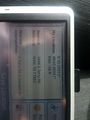
| Thu 10 Jan 2013 in 30,-93: 30.1002400, -93.9586309 geohashing.info google osm bing/os kml crox |
Location
Hash co-ordinates given by the small hash inquiry tool as 30.100240 North, 93.958631 West. Just slightly off a set of accesible train tracks near Vidor, Texas.
Started the expedition in Sam Houston Jones State Park, just outside Lake Charles, Louisiana.
While we did not complete the Hash exactly we got pretty close at 30.10073 North, 93.96047 West, within sight of the geohash.
Participants
- Toby
- Carmel
Expedition
I've been wanting to hash for a while but in my home area (Sydney, Australia) the hash is usually in the water, inaccessible bush or private property. At the moment me and my fellow geohasher Carmel are traveling cross country in a campervan from New York to Los Angeles and I was pretty excited when I checked the hash and saw that it was only about 10 miles off our planned route to Houston Texas for the day, so we decided to give it a go.
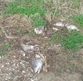
After leaving the lovely surrounds of Sam Houston Jones state park and crossing the border into Texas we turned off the I-10 and followed our GPS down through some pretty farm land towards the hash. Things started to go a little sour as we approached the hash though, I'd checked beforehand and seen that the hash was located just off a set of railway tracks that looked like we should be able to walk down them. Unfortunately as we got closer to the hash the surroundings turned from nice looking farmland to some pretty run down houses, a lot of stray dogs and more trash on the side of the road than you could poke a stick at (including the bellow pictured fish heads, which were right near the hash with two empty cases of beer and plenty of other rubbish). When we arrived at the closest point on the road to the hash at the railway crossing we felt a bit nervous about getting out and walking down the tracks since it definitely seemed like we were in the kind of place where people might not take well to that so we settled for taking a photo of the hash point and hurrying on our way.
I'm not counting this as a completed hash though I will definitely award my self the Chickened Out ribbon since that's exactly what happened.
Photos
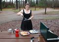
Breakfast of champions (or chickens) at the start of the hash with Carmel.
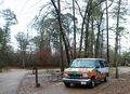
Our ride/Home for the hash and our road trip
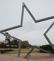
The van through the lone star at the Texas border.
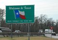
Welcome to Texas
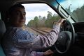
Toby with the hash point just down the tracks in the background.
Part of the reason the hash wasn't successful.
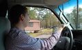
The closest we dared to go...
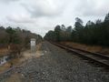
Better photo of the hash point.
More reasons we didn't quite make it.

The Geohashers?


Achievements
Toby earned the Prize poultry Consolation Prize
|