Difference between revisions of "2017-08-23 43 -85"
From Geohashing
imported>Mcbaneg m (Mcbaneg moved page 2017-08-23 42 -85 to 2017-08-23 43 -85) |
m |
||
| (One intermediate revision by one other user not shown) | |||
| Line 63: | Line 63: | ||
[[Category:Expeditions with photos]] | [[Category:Expeditions with photos]] | ||
[[Category:Coordinates not reached]] | [[Category:Coordinates not reached]] | ||
| + | [[Category:Not reached - No public access]] | ||
| + | {{location|US|MI|KN}} | ||
Latest revision as of 10:12, 16 March 2022
| Wed 23 Aug 2017 in 43,-85: 43.0209494, -85.7101698 geohashing.info google osm bing/os kml crox |
Location
right-of-way along I-96, Walker, MI
Participants
Expedition
After-work attempt, no joy.
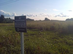
The satmap seemed to show the hashpoint at the edge of a field near the highway. Upon arrival I found that the field looked to be in the early stages of development. I parked in a little dirt parking area.
It would have been an easy walk through the field, but there was the dreaded No Trespassing sign.
I walked along the road toward the highway bridge, thinking I might be able to walk along parallel to the highway. Nope; impenetrable brush, except for one nice-looking access road, also No Trespassing.
Achievements
Mcbaneg (George) earned the No trespassing consolation prize
|


