Difference between revisions of "2013-01-16 -35 149"
From Geohashing
imported>1PE (Created page with "{{subst:Expedition |lat = -35 |lon = 149 |date = 2013-01-16}}") |
m |
||
| (4 intermediate revisions by 2 users not shown) | |||
| Line 1: | Line 1: | ||
| + | [[Image:{{{image|2013-01-16_-35_149_fence-proof.jpg}}}|thumb|left]] | ||
| − | |||
| − | |||
| − | |||
| − | |||
| − | |||
| − | |||
| − | |||
| − | |||
{{meetup graticule | {{meetup graticule | ||
| lat=-35 | | lat=-35 | ||
| Line 18: | Line 11: | ||
__NOTOC__ | __NOTOC__ | ||
== Location == | == Location == | ||
| − | + | In a field beside Majura Road, off the north end of the Canberra Airport runway, adjacent to the precision landing navigation aids. | |
== Participants == | == Participants == | ||
| − | + | *[[User:1PE|1PE]] | |
| − | |||
== Plans == | == Plans == | ||
| − | + | ===[[User:1PE|1PE]]=== | |
| + | Go after work, and then go shopping at the nearby Costco mega-mart. | ||
== Expedition == | == Expedition == | ||
| − | + | ===[[User:1PE|1PE]]=== | |
| + | I had found from the maps that the site was opposite a fence on the other side of the road. I parked opposite the fence, and found that there was a discrepancy between my map-calculated site and the GPS... of 7 paces. | ||
| − | + | The fence into the field can be seen in one picture; it is a double fence, announcing that it is part of the adjacent military firing range and that trespassing is not a good idea. The second fence is electrified. So, I did not go in. I was within about 25m of the hash point. | |
| − | + | ||
| + | I took pictures at the site then went shopping. | ||
== Photos == | == Photos == | ||
| Line 38: | Line 33: | ||
--> | --> | ||
<gallery perrow="5"> | <gallery perrow="5"> | ||
| + | Image:2013-01-16_-35+149_navaids.jpg|Navaids, hangar, and electric fence | ||
| + | Image:2013-01-16_-35_149_fence-proof.jpg|Along the line of the fence. | ||
</gallery> | </gallery> | ||
| Line 44: | Line 41: | ||
<!-- Add any achievement ribbons you earned below, or remove this section --> | <!-- Add any achievement ribbons you earned below, or remove this section --> | ||
| − | |||
| − | |||
| − | |||
| − | |||
| − | |||
| − | |||
| − | |||
| − | |||
| − | |||
| − | |||
| − | |||
[[Category:Expeditions]] | [[Category:Expeditions]] | ||
| − | |||
[[Category:Expeditions with photos]] | [[Category:Expeditions with photos]] | ||
| − | |||
| − | |||
| − | |||
| − | |||
| − | |||
| − | |||
| − | |||
| − | |||
| − | |||
[[Category:Coordinates not reached]] | [[Category:Coordinates not reached]] | ||
| − | |||
| − | |||
| − | |||
| − | |||
| − | |||
[[Category:Not reached - No public access]] | [[Category:Not reached - No public access]] | ||
| − | + | {{location|AU|ACT}} | |
| − | |||
| − | |||
| − | |||
| − | |||
| − | |||
| − | |||
| − | |||
Latest revision as of 18:00, 18 March 2022
| Wed 16 Jan 2013 in -35,149: -35.2845831, 149.1941117 geohashing.info google osm bing/os kml crox |
Location
In a field beside Majura Road, off the north end of the Canberra Airport runway, adjacent to the precision landing navigation aids.
Participants
Plans
1PE
Go after work, and then go shopping at the nearby Costco mega-mart.
Expedition
1PE
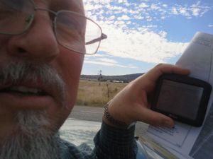
I had found from the maps that the site was opposite a fence on the other side of the road. I parked opposite the fence, and found that there was a discrepancy between my map-calculated site and the GPS... of 7 paces.
The fence into the field can be seen in one picture; it is a double fence, announcing that it is part of the adjacent military firing range and that trespassing is not a good idea. The second fence is electrified. So, I did not go in. I was within about 25m of the hash point.
I took pictures at the site then went shopping.


