Difference between revisions of "2009-12-05 -38 145"
(Road Trip Geohash) |
m |
||
| (16 intermediate revisions by 5 users not shown) | |||
| Line 1: | Line 1: | ||
| − | == | + | {{meetup graticule |
| + | | lat=-38 | ||
| + | | lon=145 | ||
| + | | date=2009-12-05 | ||
| + | }} | ||
| − | |||
| − | + | == Location == | |
| + | Pakenham graticulate | ||
| − | We headed out along the Monash and through never-ending fields of unusually green grass, low eucalypts and unusually full dams. The | + | == Participants == |
| + | * [[User:Kozz|Kozz]] | ||
| + | * Kozz's partner | ||
| + | |||
| + | |||
| + | |||
| + | == Expedition - Road trip Geohash == | ||
| + | |||
| + | When my partner told me she needed to get some kilometres up on her car (some convulted tax thing), the first thing I reached for was my netbook and shiny Chrome browser. Saturday the 5th's hash for our home graticulate in East Melbourne was waaaayyy up in the north-east, and didn't look like a very interesting drive. I really wanted to drive east of Melbourne instead, so we chose the Pakenham graticulate - a 350km round trip. | ||
| + | |||
| + | We headed out along the Monash motorway and through never-ending fields of unusually green grass, low eucalypts and unusually full dams. The TomTom told us to turn off the main highway just short of Warragul, and the scenery turned from bland motorway driving to beautiful rolling Victorian countryside. | ||
| + | |||
| + | The recent rains had greened the place up wonderfully, and it was a real pleasure to drive through the countryside in search of the distant hash. However, some areas still bore the scars from the recent bushfires in Victoria, with trees only just beginning to recover now. | ||
== Access denied by Dr Who == | == Access denied by Dr Who == | ||
| Line 11: | Line 27: | ||
The hash was on private farmland only a few kilometres north of the main highway, accessible off a gravel road. Google Maps indicated that there was some form of trail or path alongside a creek that would provide easy access to the hash point, but it transpired that said path was just a gate into a paddock, provided so water engineers could get in and access the stream. | The hash was on private farmland only a few kilometres north of the main highway, accessible off a gravel road. Google Maps indicated that there was some form of trail or path alongside a creek that would provide easy access to the hash point, but it transpired that said path was just a gate into a paddock, provided so water engineers could get in and access the stream. | ||
| − | The paddock had about thirty cows in it, and while this sounds idyllic, I have seen first hand the damage that a cow can effect upon a human, so I was unwilling to traverse either on foot or in the car. So I made do with some photos of the TomTom, the field, the gate, and the point I assume was the hash, about 100m away. One of the more inquisitive cows stuck its head forward, and | + | The paddock had about thirty cows in it, and while this sounds idyllic, I have seen first hand the damage that a cow can effect upon a human, so I was unwilling to traverse either on foot or in the car. So I made do with some photos of the TomTom, the field, the gate, and the point I assume was the hash, about 100m away. |
| + | |||
| + | <gallery perrow="3"> | ||
| + | Image:2009-12-05_-38_145_Burnt_trees.jpg | Still sad to see the burnt remains of eucalypts everywhere | ||
| + | Image:2009-12-05_-38_145-Gravel_Road.jpg | Driving down the gravel road | ||
| + | Image:2009-12-05_-38_145_Geohash_Zoomed.jpg | The hash, way in the distance | ||
| + | Image:2009-12-05_-38_145_Cows_hazardous.jpg | Hazard: Cows. Beautiful cows, but big cows. | ||
| + | Image:2009-12-05_-38_145_Close_as_i_got.jpg | As close as I got - coordinates onscreen | ||
| + | Image:2009-12-05_-38_145_Geohash_Zoomed_In.jpg | That's the hash point, just over the edge of the slope | ||
| + | </gallery> | ||
| + | |||
| + | One of the more inquisitive cows stuck its head forward, and guess what was written on its eartag...rather fitting. | ||
| + | |||
| + | [[Image:2009-12-05_-38_145-Oh_noes_its_david_tennant.jpg | Are....are you David Tennant?]] | ||
I took a couple more photos, we drove on to Traralgon, had lunch (go the Drover's Pie and chocolate Big M) and returned to Melbourne, target kilometres met, geohash reached, and fun had. | I took a couple more photos, we drove on to Traralgon, had lunch (go the Drover's Pie and chocolate Big M) and returned to Melbourne, target kilometres met, geohash reached, and fun had. | ||
| + | |||
== Highlights == | == Highlights == | ||
| + | * Meeting a cow called '''Dr Who''' that strangely resembled David Tennant | ||
| + | |||
| + | * Gippsland - beautiful at this time of the year, made me want to settle down and become a farmer on the spot | ||
| + | |||
| + | * How good is a decent pie on a Geohash? | ||
| − | |||
| − | |||
| − | + | [[Category:Not reached - No public access]][[Category:Coordinates not reached]][[Category:Expeditions with photos]][[Category:Expeditions]] | |
| + | {{location|AU|VIC|BB}} | ||
Latest revision as of 19:02, 18 March 2022
| Sat 5 Dec 2009 in -38,145: -38.0580557, 145.9298404 geohashing.info google osm bing/os kml crox |
Contents
Location
Pakenham graticulate
Participants
- Kozz
- Kozz's partner
Expedition - Road trip Geohash
When my partner told me she needed to get some kilometres up on her car (some convulted tax thing), the first thing I reached for was my netbook and shiny Chrome browser. Saturday the 5th's hash for our home graticulate in East Melbourne was waaaayyy up in the north-east, and didn't look like a very interesting drive. I really wanted to drive east of Melbourne instead, so we chose the Pakenham graticulate - a 350km round trip.
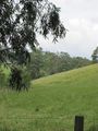
We headed out along the Monash motorway and through never-ending fields of unusually green grass, low eucalypts and unusually full dams. The TomTom told us to turn off the main highway just short of Warragul, and the scenery turned from bland motorway driving to beautiful rolling Victorian countryside.
The recent rains had greened the place up wonderfully, and it was a real pleasure to drive through the countryside in search of the distant hash. However, some areas still bore the scars from the recent bushfires in Victoria, with trees only just beginning to recover now.
Access denied by Dr Who
The hash was on private farmland only a few kilometres north of the main highway, accessible off a gravel road. Google Maps indicated that there was some form of trail or path alongside a creek that would provide easy access to the hash point, but it transpired that said path was just a gate into a paddock, provided so water engineers could get in and access the stream.
The paddock had about thirty cows in it, and while this sounds idyllic, I have seen first hand the damage that a cow can effect upon a human, so I was unwilling to traverse either on foot or in the car. So I made do with some photos of the TomTom, the field, the gate, and the point I assume was the hash, about 100m away.
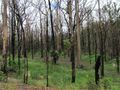
Still sad to see the burnt remains of eucalypts everywhere
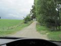
Driving down the gravel road
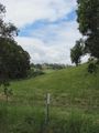
The hash, way in the distance
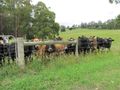
Hazard: Cows. Beautiful cows, but big cows.
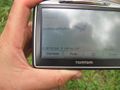
As close as I got - coordinates onscreen
That's the hash point, just over the edge of the slope


One of the more inquisitive cows stuck its head forward, and guess what was written on its eartag...rather fitting.

I took a couple more photos, we drove on to Traralgon, had lunch (go the Drover's Pie and chocolate Big M) and returned to Melbourne, target kilometres met, geohash reached, and fun had.
Highlights
- Meeting a cow called Dr Who that strangely resembled David Tennant
- Gippsland - beautiful at this time of the year, made me want to settle down and become a farmer on the spot
- How good is a decent pie on a Geohash?