Difference between revisions of "2008-05-24 47 8"
From Geohashing
imported>Ekorren (This is most probably "not reached" because of the fence visible on the picture. Recategorizing.) |
m |
||
| (3 intermediate revisions by 3 users not shown) | |||
| Line 6: | Line 6: | ||
}} | }} | ||
| + | ==Location== | ||
The coordinates are on the Zugerberg near Zug, Switzerland. | The coordinates are on the Zugerberg near Zug, Switzerland. | ||
| + | ==Participants== | ||
| + | *[[User:Adi|Adi]] + 2 | ||
| + | |||
| + | ==Expedition== | ||
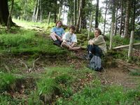
According to the photo caption (which is the only information given by the participants) and investigation of the photo and the aerial picture, the hashpoint is probably behind the fence. So it seems the point was not reached. | According to the photo caption (which is the only information given by the participants) and investigation of the photo and the aerial picture, the hashpoint is probably behind the fence. So it seems the point was not reached. | ||
| Line 20: | Line 25: | ||
[[Category:Coordinates not reached]] | [[Category:Coordinates not reached]] | ||
[[Category:Not reached - No public access]] | [[Category:Not reached - No public access]] | ||
| + | {{location|CH|ZG}} | ||
Latest revision as of 12:03, 19 March 2022
| Sat 24 May 2008 in 47,8: 47.1266480, 8.5475331 geohashing.info google osm bing/os kml crox |
Contents
Location
The coordinates are on the Zugerberg near Zug, Switzerland.
Participants
- Adi + 2
Expedition
According to the photo caption (which is the only information given by the participants) and investigation of the photo and the aerial picture, the hashpoint is probably behind the fence. So it seems the point was not reached.
Pictures
- Pictures
Three people about 20 metres in front of the coordinates
