Difference between revisions of "2010-09-11 46 -120"
From Geohashing
imported>AeroIllini |
m |
||
| (3 intermediate revisions by 3 users not shown) | |||
| Line 17: | Line 17: | ||
==The Result== | ==The Result== | ||
Success! | Success! | ||
| + | |||
| + | {{Land geohash | latitude = 46 | longitude = -120 | date = 2010-09-11 | name = Aeroillini | image = AeroIllini 2010-09-11 47 -120.jpg }} | ||
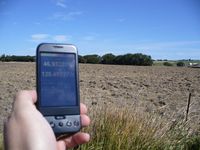
[[File:AeroIllini 2010-09-11_47_-120.jpg|200px|thumb|left|Photo within 300ft of the point.]] | [[File:AeroIllini 2010-09-11_47_-120.jpg|200px|thumb|left|Photo within 300ft of the point.]] | ||
[[Category:Expeditions]] | [[Category:Expeditions]] | ||
| + | [[Category:Expeditions with photos]] | ||
| + | [[Category:Coordinates not reached]] | ||
| + | [[Category:Not reached - No public access]] | ||
| + | {{location|US|WA|KT}} | ||
Latest revision as of 09:12, 24 April 2022
| Sat 11 Sep 2010 in 46,-120: 46.9314646, -120.4966417 geohashing.info google osm bing/os kml crox |
The Point
The point was in a private field one exit south of Ellensburg on I-82.
The Participants
AeroIllini and Tiffany.
The Expedition
The point itself was not reached, since it was on private property, but a photo was taken of the point from the road, about 300 feet distant.
The Result
Success!
Aeroillini earned the Land geohash achievement
|
