Difference between revisions of "2022-08-18 59 18"
From Geohashing
(An expedition message sent via Geohash Droid for Android.) |
([live picture]A location in the forest just north of Angarnsjöängens nature preserve. I took a car to the northern parking lot. From there I was only about 700m from the spot. I pretty much just tried to wing my way there and started on a trail that...) |
||
| Line 34: | Line 34: | ||
--> | --> | ||
<gallery perrow="5"> | <gallery perrow="5"> | ||
| + | |||
| + | Image:2022-08-18_59_18_deep-thot_1660831525810.jpg|A location in the forest just north of Angarnsjöängens nature preserve. | ||
| + | I took a car to the northern parking lot. From there I was only about 700m from the spot. I pretty much just tried to wing my way there and started on a trail that seemed to be heading in the right direction. However it soon ended in a really thick patch of deciduous trees, which I had to find my way around. It turned out to be not that big and I made my way to the spot by part bushwhacking, part following very loosely defined trails. | ||
| + | The location itself was in a bit of lighter forest, right on top of what seemed like an old forestry trail. | ||
| + | |||
| + | Going back, I did the smart thing and used the local Strava heatmaps to find a much more convenient route back to the car. | ||
</gallery> | </gallery> | ||
Revision as of 14:05, 18 August 2022
| Thu 18 Aug 2022 in 59,18: 59.5641103, 18.1742680 geohashing.info google osm bing/os kml crox |
Location
Participants
Plans
Expedition
Tracklog
Photos
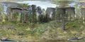
A location in the forest just north of Angarnsjöängens nature preserve.
- The location itself was in a bit of lighter forest, right on top of what seemed like an old forestry trail.
- Going back, I did the smart thing and used the local Strava heatmaps to find a much more convenient route back to the car.

Achievements