Difference between revisions of "2023-01-14 52 9"
(new report) |
(adding details) |
||
| Line 5: | Line 5: | ||
==Participants== | ==Participants== | ||
*[[User:Fippe|Fippe]] | *[[User:Fippe|Fippe]] | ||
| + | |||
| + | ==Plans== | ||
| + | I know what you are thinking: What's up with Fippe and his weird attempts to reach [[Special:Search/"marl pit" -APE|Geohashes in marl pits]]? But while the last two were obviously not reachable and I only attempted them because they were so close by, hear me out on this one: It technically is not ''in'' the pit, it is on a path on the edge of one. It could be accesible, right? And even if it isn't, it's too close to not attempt. | ||
==Expedition== | ==Expedition== | ||
| − | + | At night, I cycled to Ahlten, and from there to the edge of the marl pit. It turns out that the path I would like to access is fenced off - oh well. So I waited the few remaining minutes until midnight, recorded proof of my position, and cycled back home. | |
| + | |||
| + | ==Photos== | ||
| + | <gallery> | ||
| + | 2023-01-14 52 9 01 Gate.jpg | No public access | ||
| + | 2023-01-14 52 9 02 Proof.jpg | Proof of my position | ||
| + | </gallery> | ||
| + | |||
| + | ==Ribbons== | ||
| + | {{#vardefine:ribbonwidth|100%}} | ||
| + | {{no trespassing|date=2023-01-14|latitude=52|longitude=9|name=[[User:Fippe|Fippe]]|distance=253 m|image=2023-01-14 52 9 01 Gate.jpg}} | ||
| + | {{Radio Yerevan|achievement=[[Midnight Geohash]]|detail=he did not reach the coordinates|date=2023-01-14|latitude=52|longitude=9|user=[[User:Fippe|Fippe]]}} | ||
| + | {{Radio Yerevan|achievement=[[Bicycle Geohash]]|detail=he did not reach the coordinates|date=2023-01-14|latitude=52|longitude=9|user=[[User:Fippe|Fippe]]}} | ||
__NOTOC__ | __NOTOC__ | ||
[[Category:Expeditions]] | [[Category:Expeditions]] | ||
| + | [[Category:Expeditions with photos]] | ||
[[Category:Coordinates not reached]] | [[Category:Coordinates not reached]] | ||
[[Category:Not reached - No public access]] | [[Category:Not reached - No public access]] | ||
{{location|DE|NI|H}} | {{location|DE|NI|H}} | ||
| + | {{user categories|user=Fippe|bike=21|hours=00}} | ||
Revision as of 20:21, 14 January 2023
| Sat 14 Jan 2023 in 52,9: 52.3855083, 9.8853856 geohashing.info google osm bing/os kml crox |
Location
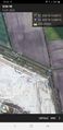
This Geohash is located on a path next to a marl pit in Hannover-Misburg.
Participants
Plans
I know what you are thinking: What's up with Fippe and his weird attempts to reach Geohashes in marl pits? But while the last two were obviously not reachable and I only attempted them because they were so close by, hear me out on this one: It technically is not in the pit, it is on a path on the edge of one. It could be accesible, right? And even if it isn't, it's too close to not attempt.
Expedition
At night, I cycled to Ahlten, and from there to the edge of the marl pit. It turns out that the path I would like to access is fenced off - oh well. So I waited the few remaining minutes until midnight, recorded proof of my position, and cycled back home.
Photos
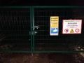
No public access
Proof of my position


Ribbons
Fippe earned the No trespassing consolation prize
|
Is it true that Fippe earned the Midnight Geohash?
|
Is it true that Fippe earned the Bicycle Geohash?
|