Difference between revisions of "2023-05-04 41 -88"
(Add gennyble's expedition below the Photos section) |
m (Remove gennyble from the first expedition section) |
||
| Line 16: | Line 16: | ||
Success, will fill out the rest later - Tara | Success, will fill out the rest later - Tara | ||
| − | |||
| − | |||
== Tracklog == | == Tracklog == | ||
<!-- if your GPS device keeps a log, you may use Template:Tracklog, post a link here, or both --> | <!-- if your GPS device keeps a log, you may use Template:Tracklog, post a link here, or both --> | ||
Revision as of 02:03, 5 May 2023
| Thu 4 May 2023 in 41,-88: 41.8220664, -88.1107722 geohashing.info google osm bing/os kml crox |
Location
Along side a trail in the Danada Forest Preserve near Warrenville.
Participants
Plans
Ride my bicycle over there around noon - Tara
Expedition
Success, will fill out the rest later - Tara
Tracklog
Photos
Expedition gennyble
The point laid in the Danada Forest Preserve, which was exciting to me! I'd been casually looking at the geohash points for a few months and this was the first one that felt close enough to go for and I had time to try and get it.
I set off around 5:30pm and arrived half an hour later, getting gas on the way. I walked the trail to the point, took a photo of my favourite hat in the quite beautiful what-looked-to-be-prairie and headed back. One day I'd like to walk to a point, but the easy route (via car) was alright for my first recorded hash.
Photos
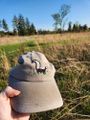
Favourite hash at the point
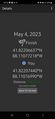
Geohash Droid proof


Achievements