Difference between revisions of "2019-05-20 51 13"
imported>Danatar m (Now with pictures) |
(→tracklog) |
||
| (One intermediate revision by one other user not shown) | |||
| Line 32: | Line 32: | ||
===tracklog=== | ===tracklog=== | ||
| − | + | {{tracklog | 2019-05-20 51 13-triton.gpx}} | |
[[Category:Expeditions]] | [[Category:Expeditions]] | ||
| Line 38: | Line 38: | ||
[[Category:Coordinates not reached]][[Category:Not reached - No public access]] | [[Category:Coordinates not reached]][[Category:Not reached - No public access]] | ||
[[Category:Danatar]] | [[Category:Danatar]] | ||
| + | {{location|DE|SN|DD}} | ||
Latest revision as of 11:16, 17 August 2023
| Mon 20 May 2019 in Dresden: 51.0306206, 13.7924388 geohashing.info google osm bing/os kml crox |
Location
Today's location is in an appartment building at Ruppendorfer Weg in Dresden-Seidnitz.
Country: Germany; state: Sachsen (Saxony, EU:DE:SN); district: Dresden; Ortsamt: Blasewitz; Stadtteil: Seidnitz/Dobritz
Weather: Alternating between light rain and no rain
Danatar
Planning
The hashpoint is not very far from my appartment, I plan to visit it after work, probably between 17 and 19 o'clock. There's a high probability that I won't reach the exact spot as it seems to be in a buildding.
Expedition
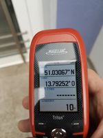
During a slowdown of the hours-long rain I started to cycle towards the hashpoint. It didn't take long to get through the Striesen and Gruna city districts to Ruppendorfer Weg and by that time the rain had completely stopped. As expected I couldn't reach the spot because it was in the building and from the door it was too far. I even went to the other side of the building but the spot was even further from there. Then I continued towards home, using the air pump of the nearby gas station to pump up my bike's tires on the way. In total I cycled 6.2 km and except for the unsuccessful GPS dance at the spot the whole expedition was done on a tron route.
|
tracklog


