Difference between revisions of "2023-10-24 47 9"
Globescorer (talk | contribs) (→Expedition) |
Globescorer (talk | contribs) (→Expedition) |
||
| Line 21: | Line 21: | ||
[[File:2023-10-24 47 9 sign 1.jpg|right|250px|]] | [[File:2023-10-24 47 9 sign 1.jpg|right|250px|]] | ||
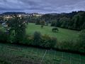
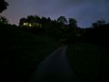
The next view is behind the Farmhouse where the "private" road goes on. very steep road... | The next view is behind the Farmhouse where the "private" road goes on. very steep road... | ||
| − | The pictures were made with the "night mode". | + | The pictures were made with the "night mode". So it got darker and darker... |
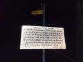
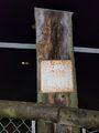
I saw a sign about the "Thurweg" on the way... | I saw a sign about the "Thurweg" on the way... | ||
Revision as of 12:39, 25 October 2023
| Tue 24 Oct 2023 in 47,9: 47.4182654, 9.0807820 geohashing.info google osm bing/os kml crox |
Contents
Location
This Geohash is located in a cow pasture near Jonschwil (SG), Switzerland.
Participants
Plans
to reach this hashpoint in the evening.
Expedition
Text and photos under construction....
After 6p.m. I drove towards the Hashpoint. Then near Jonschwil the road to the hashpoint area is only accessible for people with special permit...

So I parked the car in Jonschwil itself. From there I had to walk... After a few meters I remarked, that it would be a bit hard... because of the hilly foothills of the Alps here...

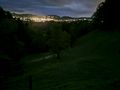
The first picture was made at the settlement of Jonschwil and we can see castle ruins behind the farmhouse up on a little hill with a white statue on top of it.

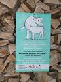
hiking signpost down at the street: "Burg" (=castle) with information about meters above sea level.

The next view is behind the Farmhouse where the "private" road goes on. very steep road... The pictures were made with the "night mode". So it got darker and darker...
I saw a sign about the "Thurweg" on the way...
So: expedition was unsuccessful...
Photos

view from Jonschwil towards the hashpoint, but not in sight

hiking signpost "Burg" (=castle) with information about meters above sea level