Difference between revisions of "Brookings, Oregon"
imported>Michael5000 |
m (per Renaming Proposal) |
||
| (3 intermediate revisions by 3 users not shown) | |||
| Line 15: | Line 15: | ||
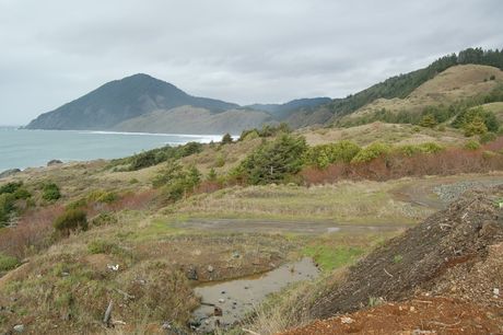
[[Image:20019-12-27 42 -124 03.jpg|460px|Humbug Mountain on the Southern Oregon Coast, from near the [[2009-12-27 42 -124|2009-12-27]] hashpoint.]] | [[Image:20019-12-27 42 -124 03.jpg|460px|Humbug Mountain on the Southern Oregon Coast, from near the [[2009-12-27 42 -124|2009-12-27]] hashpoint.]] | ||
| − | |||
| + | The Brookings, Oregon graticule is located at [[42,-124]]. {{Today's location|lat=42|lon=-124|text=Today's location.}} | ||
| + | More than half of this graticule lies over the Pacific Ocean. The land area is generally forested hills, often quite difficult to reach; much of the eastern quarter of the graticule is in the wilderness area of the Siskiyou National Forest. | ||
| + | |||
| + | Highway 101 runs along the coast, connecting the towns of Brookings, Gold Beach, and Port Orford, as well as little villages like Langlois, on the northern edge of the graticule. In the northeast corner, the very small town of Powers is the center of activity in the valley of the South Fork of the Coquille River. | ||
== Expedition History == | == Expedition History == | ||
| Line 28: | Line 31: | ||
| − | {{ | + | {{Graticule unlocked |
| latitude = 42 | | latitude = 42 | ||
| longitude = -124 | | longitude = -124 | ||
Latest revision as of 04:22, 20 March 2024
| 43,-125 | Coos Bay | Roseburg |
| 42,-125 | Brookings | Grants Pass |
| 41,-125 | Crescent City, California | Happy Camp, California |
|
Today's location: geohashing.info google osm bing/os kml crox | ||
The Brookings, Oregon graticule is located at 42,-124. Today's location.
More than half of this graticule lies over the Pacific Ocean. The land area is generally forested hills, often quite difficult to reach; much of the eastern quarter of the graticule is in the wilderness area of the Siskiyou National Forest.
Highway 101 runs along the coast, connecting the towns of Brookings, Gold Beach, and Port Orford, as well as little villages like Langlois, on the northern edge of the graticule. In the northeast corner, the very small town of Powers is the center of activity in the valley of the South Fork of the Coquille River.
Expedition History
2009-12-27
Michael5000 and Mrs.5000 reach a point just off of 101 south of Humbug Mountain
Expedition Success
Michael5000 and Mrs.5000 earned the Graticule Unlocked Achievement
|
