Difference between revisions of "2024-05-09 47 -122"
From Geohashing
Coyotebush (talk | contribs) (An expedition message sent via Geohash Droid for Android.) |
Coyotebush (talk | contribs) ([live picture]Route 22 [https://openstreetmap.org/?mlat=47.52111389&mlon=-122.36506389&zoom=16 @47.5211,-122.3651]) |
||
| (One intermediate revision by the same user not shown) | |||
| Line 25: | Line 25: | ||
<!-- how it all turned out. your narrative goes here. --> | <!-- how it all turned out. your narrative goes here. --> | ||
| + | |||
| + | *On board an H Line bus, fastest among 3 simultaneous departures to Westwood Village, to connect with infrequent route 22. -- [[User:Coyotebush|Coyotebush]] ([[User talk:Coyotebush|talk]]) [https://openstreetmap.org/?mlat=47.60467155&mlon=-122.33325985&zoom=16 @47.6047,-122.3333] 13:41, 9 May 2024 (PDT) | ||
== Tracklog == | == Tracklog == | ||
<!-- if your GPS device keeps a log, you may use Template:Tracklog, post a link here, or both --> | <!-- if your GPS device keeps a log, you may use Template:Tracklog, post a link here, or both --> | ||
| Line 33: | Line 35: | ||
--> | --> | ||
<gallery perrow="5"> | <gallery perrow="5"> | ||
| + | |||
| + | Image:2024-05-09_47_-122_coyotebush_1715289877127.jpg|Route 22 [https://openstreetmap.org/?mlat=47.52111389&mlon=-122.36506389&zoom=16 @47.5211,-122.3651] | ||
</gallery> | </gallery> | ||
Revision as of 21:24, 9 May 2024
| Thu 9 May 2024 in 47,-122: 47.5054684, -122.3886777 geohashing.info google osm bing/os kml crox |
Location
Participants
Plans
Expedition
- On board an H Line bus, fastest among 3 simultaneous departures to Westwood Village, to connect with infrequent route 22. -- Coyotebush (talk) @47.6047,-122.3333 13:41, 9 May 2024 (PDT)
Tracklog
Photos
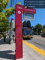
Route 22 @47.5211,-122.3651

Achievements