Difference between revisions of "1978-07-16 54 -2"
m |
m (Finally adding photos) |
||
| Line 19: | Line 19: | ||
== Photos == | == Photos == | ||
| − | + | <gallery> | |
| + | File:1978-07-16 54 -2 Geohash.jpg | At the geohash | ||
| + | File:1978-07-16 54 -2 Geohash Distance.jpg | Zoomed out of the previous | ||
| + | File:1978-07-16 54 -2 Panorama.jpg | Panorama taken from the point | ||
| + | File:1978-07-16 54 -2 KerrMcF.jpg | Me! On a pedalo at the geohash | ||
| + | File:1978-07-16 54 -2 Route.jpg | The walk to the pedalo area | ||
| + | </gallery> | ||
| − | [[Category:Retro coordinates reached]] | + | [[Category:Retro coordinates reached]] [[Category:Expeditions with photos]] |
Latest revision as of 00:01, 12 June 2024
| Sun 16 Jul 1978 in 54,-2: 54.6352709, -2.6559317 geohashing.info google osm bing/os kml crox |
Contents
Location
On the lake at Center Parcs Whinfell Forest.
Participants
- KerrMcF (retro)
- KerrMcF's family (sister, dad, mum) (retro)
Plans
KerrMcF
At around 10:45am on 2024-05-26, my family and I will be heading onto the lake on a pedalo. This point is on the lake, and since it's quite a unique way to reach a point, we will be attempting to travel through it.
Expedition
KerrMcF (Retro, 2024-05-26)
The pedalo area was only a short walk from our accommodation, so we reached it fairly quickly. We were going to be on the lake for 45 minutes, so we spent the first 30 of those pedalling to different areas. After this, I brought us over to the geohash point, which we reached successfully. It started to rain quite heavily shortly after this, so we headed back over to the pedalo area and got out a few minutes early.
Photos
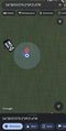
At the geohash
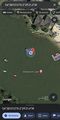
Zoomed out of the previous
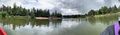
Panorama taken from the point

Me! On a pedalo at the geohash
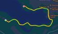
The walk to the pedalo area


