Difference between revisions of "2024-08-20 52 5"
From Geohashing
Coyotebush (talk | contribs) ([live picture]Map at parking lot [https://openstreetmap.org/?mlat=52.22887500&mlon=5.94189444&zoom=16 @52.2289,5.9419]) |
Coyotebush (talk | contribs) ([live picture]Closest approach from the west) |
||
| Line 33: | Line 33: | ||
Image:2024-08-20_52_5_coyotebush_1724150048291.jpg|Map at parking lot [https://openstreetmap.org/?mlat=52.22887500&mlon=5.94189444&zoom=16 @52.2289,5.9419] | Image:2024-08-20_52_5_coyotebush_1724150048291.jpg|Map at parking lot [https://openstreetmap.org/?mlat=52.22887500&mlon=5.94189444&zoom=16 @52.2289,5.9419] | ||
| + | |||
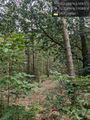
| + | Image:2024-08-20_52_5_coyotebush_1724154505911.jpg|Closest approach from the west | ||
</gallery> | </gallery> | ||
Revision as of 11:48, 20 August 2024
| Tue 20 Aug 2024 in 52,5: 52.2288004, 5.9292350 geohashing.info google osm bing/os kml crox |
Location
Participants
Plans
Expedition
Tracklog
Photos
Fence hidden by blackberries @52.2290,5.9289
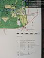
Map at parking lot @52.2289,5.9419
Closest approach from the west


Achievements