Difference between revisions of "2024-08-24 53 8"
From Geohashing
Beardygrade (talk | contribs) ([retro picture]The wet, grassy field underlying the geohash.) |
Beardygrade (talk | contribs) (→Participants) |
||
| Line 15: | Line 15: | ||
<!-- who attended: If you link to your wiki user name in this section, your expedition will be picked up by the various statistics generated for geohashing. You may use three tildes ~ as a shortcut to automatically insert the user signature of the account you are editing with. | <!-- who attended: If you link to your wiki user name in this section, your expedition will be picked up by the various statistics generated for geohashing. You may use three tildes ~ as a shortcut to automatically insert the user signature of the account you are editing with. | ||
--> | --> | ||
| + | [[User:Beardygrade|Beardygrade]] ([[User talk:Beardygrade|talk]]) | ||
== Plans == | == Plans == | ||
Revision as of 22:54, 26 August 2024
| Sat 24 Aug 2024 in 53,8: 53.1421114, 8.4906792 geohashing.info google osm bing/os kml crox |
Location
The geohash was located in a wet, grassy rural landscape (Hiddigwardermoor) between Hude and the small river Ollen. It was more or less in the center of a field accessible from the road.
Participants
Plans
Expedition
Tracklog
Photos

Proof of reaching the geohash.
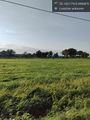
The wet, grassy field underlying the geohash.


Achievements