Difference between revisions of "2024-09-15 62 27"
From Geohashing
(Created page with "{{subst:expedition}}") |
|||
| (3 intermediate revisions by the same user not shown) | |||
| Line 1: | Line 1: | ||
| − | + | {{meetup graticule|date=2024-09-15|lat=62|lon=27}} | |
| − | + | == Location == | |
| − | + | In the forest near Kaarinlahti, Kuopio. | |
| − | |||
| − | |||
| − | |||
| − | + | The point on a topographic map: [https://kripakko.neocities.org/geohash_maplink?{{#replace:{{SUBPAGENAME}}| |_}}K] | |
| − | |||
| − | |||
| − | |||
== Participants == | == Participants == | ||
| − | + | * [[User:Kripakko|Kripakko]] | |
| − | |||
| − | == | + | == Expedition == |
| − | + | I was going to drive from Joensuu to Oulu today, and this hashpoint would be an easy visit if I would take the route via Siilinjärvi and Iisalmi. | |
| − | + | ''More story later...'' | |
| − | |||
== Tracklog == | == Tracklog == | ||
| − | + | I recorded only this short stretch around and including the diversion from the highway. | |
| + | |||
| + | {{Tracklog|2024-09-15 62 27 tracklog.gpx}} | ||
== Photos == | == Photos == | ||
| − | < | + | <gallery perrow="3"> |
| − | Image:2024- | + | Image:2024-09-15 62 27 01-car.jpg|Where I parked the car. I very likely blocked the road completely, but nobody else was using the road during the few minutes I was away. |
| − | -- | + | Image:2024-09-15 62 27 02-selfie.jpg|Selfie at the hashpoint. |
| − | + | Image:2024-09-15 62 27 03-qdgn.png|Proof of location and time, screenshot of [https://kripakko.neocities.org/qdgn QDGN]. | |
</gallery> | </gallery> | ||
== Achievements == | == Achievements == | ||
| − | {{ | + | {{Land geohash|date=2024-09-15|latitude=62|longitude=27|name=[[User:Kripakko|Kripakko]]}} |
| − | |||
__NOTOC__ | __NOTOC__ | ||
Latest revision as of 22:12, 15 September 2024
| Sun 15 Sep 2024 in 62,27: 62.9435660, 27.9466165 geohashing.info google osm bing/os kml crox |
Location
In the forest near Kaarinlahti, Kuopio.
The point on a topographic map: [1]
Participants
Expedition
I was going to drive from Joensuu to Oulu today, and this hashpoint would be an easy visit if I would take the route via Siilinjärvi and Iisalmi.
More story later...
Tracklog
I recorded only this short stretch around and including the diversion from the highway.
Photos
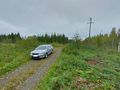
Where I parked the car. I very likely blocked the road completely, but nobody else was using the road during the few minutes I was away.
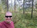
Selfie at the hashpoint.
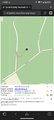
Proof of location and time, screenshot of QDGN.


Achievements
Kripakko earned the Land geohash achievement
|