Difference between revisions of "2024-09-29 43 -78"
FelixTheCat (talk | contribs) (Created page with "{{subst:Expedition}}") |
FelixTheCat (talk | contribs) |
||
| Line 1: | Line 1: | ||
| − | + | {{meetup graticule|date=2024-09-29|lat=43|lon=-78}} | |
| − | |||
| − | |||
| − | |||
| − | |||
| − | |||
| − | |||
| − | |||
| − | |||
== Location == | == Location == | ||
| − | + | By the side of the road in Orono, Ontario, Canada. | |
== Participants == | == Participants == | ||
| − | + | * [[User:FelixTheCat|FelixTheCat]] ([[User talk:FelixTheCat|talk]]) | |
| − | + | * Kat the Awesome | |
| − | |||
| − | |||
| − | |||
== Expedition == | == Expedition == | ||
| − | + | Kat and I were on a two-week road trip through eastern Canada. On our second-to-last day we finally had a hashpoint close to our planned route and on publicly accessible land. So we took the required ten-minute detour on our way to Toronto, carefully pulled up to the point, and sadly discovered that it was in someone's front yard. And it wasn't simply on the lawn either: it looked like we'd have to go crawl under some trees and bushes to get there. Neither of us felt like ringing the doorbell and asking for such a weird thing, so we decided to let this one go and continued on our journey. | |
| − | |||
| − | |||
| − | |||
== Photos == | == Photos == | ||
| − | |||
| − | |||
| − | |||
<gallery perrow="5"> | <gallery perrow="5"> | ||
| + | Image:2024-09-29 43 -78 FelixTheCat 1.JPG | Ochonski Road looks like a typical rural road in this area. | ||
| + | Image:2024-09-29 43 -78 FelixTheCat 2.JPG | It's a bit hilly, and there are houses here and there. | ||
| + | Image:2024-09-29 43 -78 FelixTheCat 3.JPG | We've stopped in front of the hash. The point is somewhere behind that big tree. | ||
| + | Image:2024-09-29 43 -78 FelixTheCat 4.png | The closest we got was about 18 metres. | ||
| + | Image:2024-09-29 43 -78 FelixTheCat 5.JPG | Lloyd is disappointed. | ||
</gallery> | </gallery> | ||
== Achievements == | == Achievements == | ||
{{#vardefine:ribbonwidth|100%}} | {{#vardefine:ribbonwidth|100%}} | ||
| − | + | {{No trespassing | |
| + | | latitude = 43 | ||
| + | | longitude = -78 | ||
| + | | date = 2024-09-29 | ||
| + | | name = [[User:FelixTheCat|FelixTheCat]] ([[User talk:FelixTheCat|talk]]) and Kat | ||
| + | | distance = 18 m | ||
| + | }} | ||
__NOTOC__ | __NOTOC__ | ||
| − | |||
| − | |||
| − | |||
| − | |||
| − | |||
| − | |||
| − | |||
| − | |||
| − | |||
| − | |||
[[Category:Expeditions]] | [[Category:Expeditions]] | ||
| − | |||
[[Category:Expeditions with photos]] | [[Category:Expeditions with photos]] | ||
| − | |||
| − | |||
| − | |||
| − | |||
| − | |||
| − | |||
| − | |||
[[Category:Coordinates not reached]] | [[Category:Coordinates not reached]] | ||
| − | |||
| − | |||
| − | |||
| − | |||
| − | |||
[[Category:Not reached - No public access]] | [[Category:Not reached - No public access]] | ||
| − | |||
| − | |||
| − | |||
| − | |||
| − | |||
Revision as of 19:51, 17 October 2024
| Sun 29 Sep 2024 in 43,-78: 43.9799051, -78.6292511 geohashing.info google osm bing/os kml crox |
Location
By the side of the road in Orono, Ontario, Canada.
Participants
- FelixTheCat (talk)
- Kat the Awesome
Expedition
Kat and I were on a two-week road trip through eastern Canada. On our second-to-last day we finally had a hashpoint close to our planned route and on publicly accessible land. So we took the required ten-minute detour on our way to Toronto, carefully pulled up to the point, and sadly discovered that it was in someone's front yard. And it wasn't simply on the lawn either: it looked like we'd have to go crawl under some trees and bushes to get there. Neither of us felt like ringing the doorbell and asking for such a weird thing, so we decided to let this one go and continued on our journey.
Photos
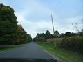
Ochonski Road looks like a typical rural road in this area.
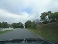
It's a bit hilly, and there are houses here and there.
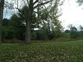
We've stopped in front of the hash. The point is somewhere behind that big tree.
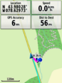
The closest we got was about 18 metres.
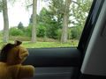
Lloyd is disappointed.


Achievements
FelixTheCat (talk) and Kat earned the No trespassing consolation prize
|