Difference between revisions of "2025-03-18 50 14"
| (One intermediate revision by the same user not shown) | |||
| Line 41: | Line 41: | ||
== Tracklog == | == Tracklog == | ||
| − | + | <span style="color:#0000ff">Blue = bus and short walk</span>, | |
| + | <span style="color:#ff0000">red = walking</span>, | ||
| + | <span style="color:#000000">black = GPS signal lost in the metro</span>. | ||
| + | |||
| + | {{tracklog|2025-03-18 50 14 tracklog.gpx}} | ||
== Photos == | == Photos == | ||
| − | < | + | <gallery perrow="9"> |
| − | Image: | + | Image:2025-03-18_50_14_01-sunshine.jpg | Sunshine in Vestec. |
| − | + | Image:2025-03-18_50_14_02-zámek.jpg | Zámek Brnky. I could not get closer because the yard was fenced. | |
| + | Image:2025-03-18_50_14_03-village1.jpg | View to Brnky village from the south. | ||
| + | Image:2025-03-18_50_14_04-pub.jpg | The local pub. | ||
| + | Image:2025-03-18_50_14_05-crossroads.jpg | I had to be careful with some of these roads so I would take wrong turns. | ||
| + | Image:2025-03-18_50_14_06-village2.jpg | View to Brnky village from the north. | ||
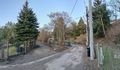
| + | Image:2025-03-18_50_14_07-alley.jpg | Entering Skopec alley. | ||
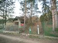
| + | Image:2025-03-18_50_14_08-gpsr.jpg | The closest to the hashpoint I could go. | ||
| + | Image:2025-03-18_50_14_09-sunset.jpg | The sun has set. | ||
</gallery> | </gallery> | ||
| − | |||
== Achievements == | == Achievements == | ||
Latest revision as of 17:42, 20 March 2025
| Tue 18 Mar 2025 in 50,14: 50.1605104, 14.4091869 geohashing.info google osm bing/os kml crox |
Location
On Skopec alley in Brnky, Zdiby.
Participants
Plans
I plan to:
- Catch bus 411 at Kobylisy metro station at 17:35
- Arrive at Zdiby,Brnky bus stop at 17:52
- Explore the area: have a look at Zámek Brnky and visit the hashpoint
- Catch bus 411 at Zdiby,Holosmetky bus stop at 18:46 and get back to Kobylisy metro station.
Looking at maps and aerial photos, I am not absolutely sure whether the alley is legally accessible, but I believe it should be. Depending on how accurate the maps are, the hashpoint may actually be slightly off the alley into a yard, but getting to within GPS uncertainty should be possible.
Expedition
I left from Vestec early enough that I would reach Kobylisy about 15 minutes before the bus departure time. It turned out to be a good idea since all the buses were more or less late. I caught bus 339 which was already a bit late, then got stuck in traffic and eventually reached Budějovická metro station about five minutes late. Then I rode metro C to Kobylisy and had nine minutes to find the correct bus stop. I followed signs towards buses to Zdiby, which put me to the surface near a junction with no bus stops in sight. Fine, no problem, I will just figure out which way to go... I saw a street sign, oriented the map accordingly and began to walk in a direction that led to a bus stop like I expected. However, it was a wrong bus stop, so I dug out the GPS receiver to see which way I had walked. It turned out that I had followed the wrong road, but I thankfully still had enough time to reach the correct stop. I quickly walked there with a couple of minutes to spare and was very thankful for having reserved the extra time.
I rode bus 411 to Brnky and started to slowly walk towards the hashpoint. The village was very beautiful, consisting of houses and big yards around a valley, and I could not resist stopping often and taking a lot of photos. I got to Skopec alley pretty easily, but there I sadly found out that the hashpoint was four metres into a fenced yard that I could not access. Damn! I had hoped that I could get within GPS uncertainty, but minimal surveying error and the fence right next to the alley made it impossible. I did not want to trespass, and nobody was home, so I could not even ask for a permission to enter. Oh well, it was still a nice little adventure, and I got a bunch of good photos. I walked to the bus stop where the returning bus 411 would leave and caught it as planned. Once in Prague again, I took metro C to Kačerov and bus 138 to Krč without much difficulty.
Tracklog
Blue = bus and short walk, red = walking, black = GPS signal lost in the metro.
Photos

Sunshine in Vestec.
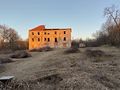
Zámek Brnky. I could not get closer because the yard was fenced.
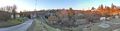
View to Brnky village from the south.
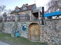
The local pub.
I had to be careful with some of these roads so I would take wrong turns.
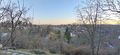
View to Brnky village from the north.
Entering Skopec alley.
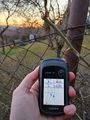
The closest to the hashpoint I could go.

The sun has set.


Achievements
Kripakko earned the No trespassing consolation prize
|