Difference between revisions of "Esbjerg, Denmark"
From Geohashing
imported>Nesk (Moved 2010-08-21 55 8 from "Planning" to "Past", corrected Danish placename orthography.) |
Leidenfrost (talk | contribs) (→Map and stats: updated map from Admin 2 to Admin 4) |
||
| (12 intermediate revisions by 5 users not shown) | |||
| Line 10: | Line 10: | ||
| e = [[Kolding, Denmark|Kolding]] | | e = [[Kolding, Denmark|Kolding]] | ||
| sw = [[Helgoland, Germany]] | | sw = [[Helgoland, Germany]] | ||
| − | | s = [[ | + | | s = [[Westerland, Germany]] |
| se = [[Flensburg, Germany]] | | se = [[Flensburg, Germany]] | ||
}} | }} | ||
| − | + | {{Today's location|lat=55|lon=8}} | |
This graticule mostly contains water and Danish parts of the North Sea coast, as well as a bit of German island Sylt at the southern edge. | This graticule mostly contains water and Danish parts of the North Sea coast, as well as a bit of German island Sylt at the southern edge. | ||
| + | |||
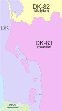
| + | ===Map and stats=== | ||
| + | [[File:Region 55,8 Admin 4.svg|200px]] | ||
| + | {| class="wikitable" | ||
| + | !Name!!code!!area type!!country!!Geohash<br />probability | ||
| + | |- | ||
| + | |<span style="color:rgba(235,206,242,255)">■</span> Syddanmark||DK-83||land||Denmark||48.0% | ||
| + | |- | ||
| + | |<span style="color:rgba(251,251,196,255)">■</span> Midtjylland||DK-82||land||Denmark||12.1% | ||
| + | |- | ||
| + | |<span style="color:rgba(251,251,196,255)">■</span> Schleswig-Holstein||DE-SH||land||Germany||0.25% | ||
| + | |- | ||
| + | |<span style="color:rgba(216,220,248,255)">■</span> Denmark||DK||incl. waters||Denmark||95.2% | ||
| + | |- | ||
| + | |<span style="color:rgba(226,244,223,255)">■</span> Schleswig-Holstein||DE-SH||incl. waters||Germany||3.6% | ||
| + | |} | ||
== Local Geohashers == | == Local Geohashers == | ||
| Line 23: | Line 39: | ||
== Past Geohashes == | == Past Geohashes == | ||
| + | *[[2022-07-02 55 8]] on Sylt, visited by [[User:Fippe|Fippe]], [[User:Leidenfrost|Leidenfrost]] and [[User:π π π|π π π]] | ||
*[[2010-08-21 55 8]] in a field near Visby, north of Tønder. A meetup of four geohashers was planned for around 13:30. | *[[2010-08-21 55 8]] in a field near Visby, north of Tønder. A meetup of four geohashers was planned for around 13:30. | ||
| − | |||
[[Category:Denmark]] | [[Category:Denmark]] | ||
[[Category:Germany]] | [[Category:Germany]] | ||
[[Category:Inactive graticules]] | [[Category:Inactive graticules]] | ||
Latest revision as of 04:10, 24 January 2023
| North Sea | Herning | Silkeborg |
| North Sea | Esbjerg | Kolding |
| Helgoland, Germany | Westerland, Germany | Flensburg, Germany |
|
Today's location: geohashing.info google osm bing/os kml crox | ||
Today's location This graticule mostly contains water and Danish parts of the North Sea coast, as well as a bit of German island Sylt at the southern edge.
Map and stats
| Name | code | area type | country | Geohash probability |
|---|---|---|---|---|
| ■ Syddanmark | DK-83 | land | Denmark | 48.0% |
| ■ Midtjylland | DK-82 | land | Denmark | 12.1% |
| ■ Schleswig-Holstein | DE-SH | land | Germany | 0.25% |
| ■ Denmark | DK | incl. waters | Denmark | 95.2% |
| ■ Schleswig-Holstein | DE-SH | incl. waters | Germany | 3.6% |
Local Geohashers
None, yet.
Planning
Past Geohashes
- 2022-07-02 55 8 on Sylt, visited by Fippe, Leidenfrost and π π π
- 2010-08-21 55 8 in a field near Visby, north of Tønder. A meetup of four geohashers was planned for around 13:30.
