Difference between revisions of "User:Grumpy"
From Geohashing
imported>Grumpy |
imported>Jiml m (Clean up to avoid confusion with Expedition reports) |
||
| (15 intermediate revisions by 2 users not shown) | |||
| Line 1: | Line 1: | ||
| − | + | = Meetup on 2009-01-31 at 32, -117 (San Diego) = | |
| − | [[ | + | |
| − | + | [[2009-01-31_32_-117|Expedition report]] | |
| − | |||
| − | |||
| − | |||
| − | | | ||
| − | |||
| − | |||
| − | |||
| − | |||
| − | |||
== Participants == | == Participants == | ||
| − | Grumpy | + | Grumpy, Mrs Grumpy |
| − | == | + | == About== |
| + | My first attempt at Geo Hashing was in San Dieguito Regional Park, just a few feet from the parking lot. Easy to get to, but had to pay. | ||
== Expedition == | == Expedition == | ||
| + | Easy to get to, just 20 minutes from my house. Was there at 4pm, but no one else arrived. | ||
| − | == | + | == Photos == |
| + | <gallery> | ||
| + | Image:P1000526.JPG| Grumpy with stupid grin | ||
| + | Image:2009-01-31 32 -117 Parking.JPG | Parking receipt | ||
| + | </gallery> | ||
| − | |||
| − | + | [[Category: Meetup on 2009-01-31]] | |
| − | + | [[Category: Meetup in 32 -117]] | |
| − | |||
| − | |||
| − | + | == Achievements == | |
| − | + | {{land geohash | |
| − | + | | latitude = 32 | |
| − | + | | longitude = -117 | |
| + | | date = 2009-01-31 | ||
| + | | name = Grumpy | ||
| + | | image = P1000526.JPG | ||
| + | }} | ||
| − | + | {{Admit One geohash | latitude = 32| longitude = -117| date = 2009-01-31 | price = $3 | venue = San Dieguito Regional Park | name = Grumpy| image =2009-01-31 32 -117 Parking.JPG }} | |
| − | |||
| − | -- | ||
| − | |||
| − | |||
| − | |||
| − | |||
| − | |||
| − | |||
| − | |||
| − | |||
| − | |||
| − | + | {{drag-along | |
| − | + | | latitude = 32 | |
| − | - | + | | longitude = -117 |
| − | + | | date = 2009-01-31 | |
| − | + | | partner = Mrs Grumpy | |
| − | + | | name = Grumpy | |
| − | + | }} | |
| − | |||
Latest revision as of 17:51, 7 February 2010
Contents
Meetup on 2009-01-31 at 32, -117 (San Diego)
Participants
Grumpy, Mrs Grumpy
About
My first attempt at Geo Hashing was in San Dieguito Regional Park, just a few feet from the parking lot. Easy to get to, but had to pay.
Expedition
Easy to get to, just 20 minutes from my house. Was there at 4pm, but no one else arrived.
Photos
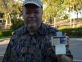
Grumpy with stupid grin
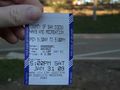
Parking receipt


Achievements
Grumpy earned the Land geohash achievement
|
Grumpy earned the Admit One Achievement
|
Grumpy earned the Drag-along achievement
|