Difference between revisions of "User:Zigdon"
imported>Zigdon |
|||
| (15 intermediate revisions by 3 users not shown) | |||
| Line 1: | Line 1: | ||
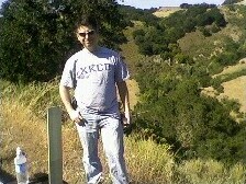
[[Image:Zigdon.jpg|frame|right]] | [[Image:Zigdon.jpg|frame|right]] | ||
| + | {{ASG|Y=1972|m=09|d=28|gender=m|lat=37|lon=-122}} | ||
| − | + | Dan Boger, currently living in the [[San Francisco, California|San Francisco]] area, CA, USA. | |
| − | Dan Boger, currently living in the [[San Francisco]] area, CA, USA. | + | My reference implementation of the hashing algorithm: http://carabiner.peeron.com/xkcd/map/map.html. |
| − | My reference implementation of the hashing algorithm: http:// | ||
== Locations I've scouted == | == Locations I've scouted == | ||
| Line 14: | Line 14: | ||
[[2008-06-01_37_-121]] - offramp of 880 on Coleman, trivial to get to, got a nice group even though it was a Sunday. | [[2008-06-01_37_-121]] - offramp of 880 on Coleman, trivial to get to, got a nice group even though it was a Sunday. | ||
| + | |||
| + | [[2008-06-07_37_-122]] - Another water point, but rode the bike to the bridge, met CWolves there, and scaled a razorwire fence to walk on the pier. Got a nasty sunburn on both arms. | ||
| + | |||
| + | [[2008-06-14 37 -122]] | ||
| + | |||
| + | [[2008-06-16 37 -122]] - Rode to the hash after work, ran in to TW there after riding into the nursery. | ||
== Achievements == | == Achievements == | ||
<gallery> | <gallery> | ||
Image:Landgeohash.png|Land Geohash | Image:Landgeohash.png|Land Geohash | ||
| + | Image:Bikegeohashing.png|Bicycle Geohasher | ||
</gallery> | </gallery> | ||
| + | |||
| + | {{Land geohash | ||
| + | | latitude=37 | ||
| + | | longitude=-121 | ||
| + | | date=2008-06-01 | ||
| + | | image = 2008-06-01-a.JPG | ||
| + | }} | ||
| + | |||
| + | {{Bicycle geohash | ||
| + | | latitude = 37 | ||
| + | | longitude = -122 | ||
| + | | date = 2008-06-07 | ||
| + | | image = IMG 1219.jpg | ||
| + | }} | ||
| + | |||
| + | {{Bicycle geohash | ||
| + | | latitude = 37 | ||
| + | | longitude = -122 | ||
| + | | date = 2008-06-16 | ||
| + | | image = 20080616-37W122.jpg | ||
| + | }} | ||
| + | |||
| + | ---- | ||
| + | |||
| + | [[User:Zigdon/sandbox]] | ||
Latest revision as of 10:49, 26 September 2011
Dan Boger, currently living in the San Francisco area, CA, USA. My reference implementation of the hashing algorithm: http://carabiner.peeron.com/xkcd/map/map.html.
Locations I've scouted
2008-05-17_37_-122 with xkcd and emad, before the site was launched. Nice wooded area, near a house that said "we don't call 911, we shoot first".
2008-05-21_37_-121 with relsqui. First point after the launch, which in lieu of going swimming in the SF graticule, we went to the East Bay one instead. Santa Cruz mountains, the road got 150m from the point then had about 150ft drop.
2008-05-24_37_-121. Ran into Joe(+2 young kids) on the way there. Tried to climb up the mountain, but too steep and too many thorny bushes stopped me about 500m from the target. On the way out, ran into a number of other geohashers, and ended up having a very nice picnic.
2008-06-01_37_-121 - offramp of 880 on Coleman, trivial to get to, got a nice group even though it was a Sunday.
2008-06-07_37_-122 - Another water point, but rode the bike to the bridge, met CWolves there, and scaled a razorwire fence to walk on the pier. Got a nasty sunburn on both arms.
2008-06-16 37 -122 - Rode to the hash after work, ran in to TW there after riding into the nursery.
Achievements
This user earned the Land geohash achievement
|
This user earned the Bicycle geohash achievement
|
This user earned the Bicycle geohash achievement
|


