Difference between revisions of "2008-05-21 37 -121"
From Geohashing
imported>Zigdon |
imported>FippeBot m (Location) |
||
| (10 intermediate revisions by 8 users not shown) | |||
| Line 1: | Line 1: | ||
| − | {{graticule | | + | {{meetup graticule |
| + | | lat=37 | ||
| + | | lon=-121 | ||
| + | | date=2008-05-21 | ||
| + | | graticule_name=San Jose, California | ||
| + | }} | ||
| − | == | + | |
| − | These coordinates were located in the [[ | + | == Location == |
| + | In the Santa Cruz Mountains. | ||
| + | |||
| + | |||
| + | These coordinates were located in the [[San Jose, California]] graticule on [[2008-05-21]], in the Santa Cruz mountains. | ||
37.179468°, -121.861536° | 37.179468°, -121.861536° | ||
| + | |||
| + | == Expedition Report == | ||
Not quite reachable from the road, we got within 150m of the actual point. | Not quite reachable from the road, we got within 150m of the actual point. | ||
| Line 10: | Line 21: | ||
== People == | == People == | ||
| − | People who | + | People who tried to reach these coordinates: |
==== 4pm PDT ==== | ==== 4pm PDT ==== | ||
| Line 20: | Line 31: | ||
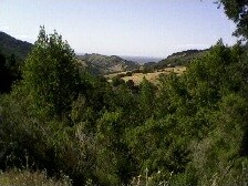
[[Image:Eastbayca-may21.jpg|Taken by Relsqui]] | [[Image:Eastbayca-may21.jpg|Taken by Relsqui]] | ||
| + | |||
| + | [[Category:Expeditions]] | ||
| + | [[Category:Expeditions with photos]] | ||
| + | [[Category:Coordinates not reached]] | ||
| + | [[Category:Not reached - Unknown]] | ||
| + | {{location|US|CA|SL}} | ||
Latest revision as of 03:59, 7 August 2019
| Wed 21 May 2008 in San Jose, California: 37.1794680, -121.8615360 geohashing.info google osm bing/os kml crox |
Location
In the Santa Cruz Mountains.
These coordinates were located in the San Jose, California graticule on 2008-05-21, in the Santa Cruz mountains.
37.179468°, -121.861536°
Expedition Report
Not quite reachable from the road, we got within 150m of the actual point.
People
People who tried to reach these coordinates:
