Difference between revisions of "2009-09-25 33 -116"
imported>Rs (→Participants: i was here) |
imported>FippeBot m (Location) |
||
| (12 intermediate revisions by 2 users not shown) | |||
| Line 1: | Line 1: | ||
| − | |||
| − | |||
| − | |||
| − | |||
{{meetup graticule | {{meetup graticule | ||
| lat=33 | | lat=33 | ||
| Line 9: | Line 5: | ||
}} | }} | ||
| − | |||
| − | |||
== Location == | == Location == | ||
| Line 17: | Line 11: | ||
== Participants == | == Participants == | ||
| − | * [[User: | + | * [[User:Rs|Richard Soderberg]] |
== Plans == | == Plans == | ||
| + | Drive there and hopefully take a picture of the lake. | ||
== Expedition == | == Expedition == | ||
| + | Not having a boat car, I decided to go for the northeast graticule. Drove from Solana Beach through Poway, down progressively smaller and smaller roads. On the way there were hills covered in enormous boulders. I ended up parking about a half a mile away from the destination and walking down a dirt road covered in small avocados. There was some sort of farm to the left and another boulder-covered hill off to the right. The road ended at a fence with a beautiful view of Lake Ramona and a variety of avocado trees and stuff. Yay! | ||
== Tracklog == | == Tracklog == | ||
| + | [http://www.everytrail.com/view_trip.php?trip_id=367793 Track log with photos] | ||
== Photos == | == Photos == | ||
| − | + | [http://www.flickr.com/photos/rsoderberg/tags/2009092533116/ More photos at Flickr] | |
| − | + | ||
| − | |||
| − | |||
| − | |||
<gallery perrow="3"> | <gallery perrow="3"> | ||
| − | + | Image:2009-09-25 33 -116 Ramona Lake.jpg | Ramona Lake. | |
| + | Image:2009-09-25 33 -116 Snail.jpg | A friendly snail. | ||
| + | Image:2009-09-25 33 -116 Almost.jpg | Almost, but not quite. | ||
</gallery> | </gallery> | ||
| + | = Results = | ||
| − | + | The point itself was in the middle of a grove of trees behind barbed-wire fence, so I took a picture from 45 meters away. | |
| − | + | ||
| − | [[ | + | {{No trespassing |
| − | -- | + | | latitude = 33 |
| + | | longitude = -116 | ||
| + | | date = 2009-09-25 | ||
| + | | name = [[User:Rs|Richard Soderberg]] | ||
| + | | image = 2009-09-25 33 -116 Ramona Lake.jpg | ||
| + | }} | ||
| − | |||
[[Category:Expeditions]] | [[Category:Expeditions]] | ||
| − | |||
[[Category:Expeditions with photos]] | [[Category:Expeditions with photos]] | ||
| − | |||
| − | |||
| − | |||
| − | |||
| − | |||
| − | |||
| − | |||
| − | |||
[[Category:Coordinates not reached]] | [[Category:Coordinates not reached]] | ||
| − | |||
| − | |||
[[Category:Not reached - No public access]] | [[Category:Not reached - No public access]] | ||
| − | + | {{location|US|CA|SD}} | |
| − | |||
| − | |||
Latest revision as of 05:58, 8 August 2019
| Fri 25 Sep 2009 in 33,-116: 33.0228332, -116.9926008 geohashing.info google osm bing/os kml crox |
Location
The meeting point was in an avocado tree farm just south of Lake Ramona, just a few meters away from 15500 Via Dena Loma, Ramona, CA.
Participants
Plans
Drive there and hopefully take a picture of the lake.
Expedition
Not having a boat car, I decided to go for the northeast graticule. Drove from Solana Beach through Poway, down progressively smaller and smaller roads. On the way there were hills covered in enormous boulders. I ended up parking about a half a mile away from the destination and walking down a dirt road covered in small avocados. There was some sort of farm to the left and another boulder-covered hill off to the right. The road ended at a fence with a beautiful view of Lake Ramona and a variety of avocado trees and stuff. Yay!
Tracklog
Photos

Ramona Lake.
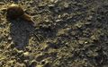
A friendly snail.
Almost, but not quite.


Results
The point itself was in the middle of a grove of trees behind barbed-wire fence, so I took a picture from 45 meters away.
Richard Soderberg earned the No trespassing consolation prize
|