Difference between revisions of "2010-06-05 45 -123"
imported>Jiml (First pass at my report) |
imported>FippeBot m (Location) |
||
| (3 intermediate revisions by 2 users not shown) | |||
| Line 5: | Line 5: | ||
}} | }} | ||
| − | |||
__NOTOC__ | __NOTOC__ | ||
== Location == | == Location == | ||
| Line 14: | Line 13: | ||
== Plans == | == Plans == | ||
| − | Park on the nearby road, and walk a little way in | + | Park on the nearby road, and walk a little way in publicly accessible forestland to get to the hashpoint. |
== Expedition == | == Expedition == | ||
| − | It proved to all be farm land in the area, so it was off limits. | + | It proved to all be farm land in the area, so it was off limits. My GPS was also reporting that |
| + | the hashpoint was a mile away from the roadway, which didn't make sense at the time. | ||
| + | Later close examination of Google Maps revealed that I really was more than a mile from the hashpoint. | ||
| + | It turns out that for some reason Google Maps is moving the hashpoint to the nearest road | ||
| + | instead of leaving it off-road. This caused me to believe it was close | ||
| + | to the roadway: Hence the confusion. | ||
| − | = | + | I'm pretty sure that in the past Google Maps has kept the hashpoint off=road, but it isn't doing |
| − | + | that in this case. Regardless, the private land was preventing access. | |
| − | |||
| − | |||
| − | |||
| + | == Photos == | ||
<gallery perrow="5"> | <gallery perrow="5"> | ||
| + | Image:2010-06-05_45_-123-area1.jpg | Area around the hashpoint | ||
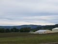
| + | Image:2010-06-05_45_-123-area3.jpg | Area around the hashpoint | ||
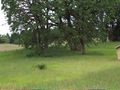
| + | Image:2010-06-05_45_-123-area2.jpg | Across the road | ||
| + | Image:2010-06-05_45_-123-livestock.jpg | Some creatures I saw on the way there | ||
</gallery> | </gallery> | ||
== Achievements == | == Achievements == | ||
{{#vardefine:ribbonwidth|800px}} | {{#vardefine:ribbonwidth|800px}} | ||
| − | |||
| − | |||
* No Trespassing | * No Trespassing | ||
| − | |||
| − | |||
| − | |||
| − | |||
[[Category:Expeditions]] | [[Category:Expeditions]] | ||
| − | |||
[[Category:Expeditions with photos]] | [[Category:Expeditions with photos]] | ||
[[Category:Coordinates not reached]] | [[Category:Coordinates not reached]] | ||
| − | |||
| − | |||
[[Category:Not reached - No public access]] | [[Category:Not reached - No public access]] | ||
| + | {{location|US|OR|YA}} | ||
Latest revision as of 02:18, 9 August 2019
| Sat 5 Jun 2010 in 45,-123: 45.4318804, -123.2300218 geohashing.info google osm bing/os kml crox |
Location
Farmland near Gaston, Oregon
Participants
Plans
Park on the nearby road, and walk a little way in publicly accessible forestland to get to the hashpoint.
Expedition
It proved to all be farm land in the area, so it was off limits. My GPS was also reporting that the hashpoint was a mile away from the roadway, which didn't make sense at the time.
Later close examination of Google Maps revealed that I really was more than a mile from the hashpoint. It turns out that for some reason Google Maps is moving the hashpoint to the nearest road instead of leaving it off-road. This caused me to believe it was close to the roadway: Hence the confusion.
I'm pretty sure that in the past Google Maps has kept the hashpoint off=road, but it isn't doing that in this case. Regardless, the private land was preventing access.
Photos
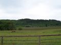
Area around the hashpoint
Area around the hashpoint
Across the road
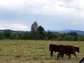
Some creatures I saw on the way there


Achievements
- No Trespassing