Difference between revisions of "2011-06-30 55 13"
imported>Fasanen (Created page with "{{subst:Expedition |lat = 55 |lon = 13 |date = 2011-06-30 }}") |
imported>FippeBot m (Location) |
||
| (One intermediate revision by one other user not shown) | |||
| Line 1: | Line 1: | ||
| − | |||
| − | |||
| − | |||
| − | |||
| − | |||
| − | |||
| − | |||
| − | |||
| − | |||
| − | |||
{{meetup graticule | {{meetup graticule | ||
| lat=55 | | lat=55 | ||
| Line 14: | Line 4: | ||
| date=2011-06-30 | | date=2011-06-30 | ||
}} | }} | ||
| − | |||
| − | |||
__NOTOC__ | __NOTOC__ | ||
== Location == | == Location == | ||
| − | + | Skeet shooting ground, eastern outskirts of Malmö. | |
== Participants == | == Participants == | ||
| − | + | * [[User:Fasanen|Fasanen]] | |
== Plans == | == Plans == | ||
| − | + | Check out the hash after work. | |
== Expedition == | == Expedition == | ||
| − | + | Last week I was staying on the island of Bornholm which despite its small size is situated in four graticules. During my stay between June 18 and 25, the geohashing algorithm effectively missed the island. What a drag! | |
| − | + | Today was the last day of June and I had not been to a geohash for the whole month. Luckily today’s coordinates struck a seemingly easy spot to reach in the outskirts of Malmö. | |
| − | |||
| + | I was not entirely sure what kind of place it was going to be when I left work in the evening. I knew it was going to be in an open grassy space close to some small buildings. Probably training ground for dogs or similar. | ||
| + | |||
| + | When I arrived it turned out to be a skeet shooting ground and yes - people were blazing away! The geohash spot was right in the line of fire so I chickened out 18 meters from target and had to settle with the consolidation prize for cowards. | ||
| + | |||
== Photos == | == Photos == | ||
| − | < | + | <gallery perrow="4"> |
| − | Image: | + | Image:551320110630 01.JPG | The entrance. |
| − | + | Image:551320110630 02.JPG | Shooters. | |
| − | + | Image:551320110630 03.JPG | The small red piece of clay marks the approximate coordinates. | |
</gallery> | </gallery> | ||
== Achievements == | == Achievements == | ||
{{#vardefine:ribbonwidth|800px}} | {{#vardefine:ribbonwidth|800px}} | ||
| − | + | {{Prize poultry | |
| − | + | | latitude = 55 | |
| − | + | | longitude = 13 | |
| − | + | | date = 2011-06-30 | |
| − | + | | name = Fasanen | |
| − | + | | reason = fear of getting shot | |
| − | + | }} | |
| − | |||
| − | |||
| − | |||
| − | |||
| − | |||
[[Category:Expeditions]] | [[Category:Expeditions]] | ||
| − | |||
[[Category:Expeditions with photos]] | [[Category:Expeditions with photos]] | ||
| − | |||
| − | |||
| − | |||
| − | |||
| − | |||
| − | |||
| − | |||
| − | |||
| − | |||
[[Category:Coordinates not reached]] | [[Category:Coordinates not reached]] | ||
| − | + | [[Category:Not reached - No public access]] | |
| − | + | [[Category:Sweden]] | |
| − | [[Category:Not reached - No public access]] | + | {{location|SE|M}} |
| − | [[Category: | ||
| − | |||
| − | |||
Latest revision as of 06:57, 9 August 2019
| Thu 30 Jun 2011 in 55,13: 55.5819397, 13.0887852 geohashing.info google osm bing/os kml crox |
Location
Skeet shooting ground, eastern outskirts of Malmö.
Participants
Plans
Check out the hash after work.
Expedition
Last week I was staying on the island of Bornholm which despite its small size is situated in four graticules. During my stay between June 18 and 25, the geohashing algorithm effectively missed the island. What a drag!
Today was the last day of June and I had not been to a geohash for the whole month. Luckily today’s coordinates struck a seemingly easy spot to reach in the outskirts of Malmö.
I was not entirely sure what kind of place it was going to be when I left work in the evening. I knew it was going to be in an open grassy space close to some small buildings. Probably training ground for dogs or similar.
When I arrived it turned out to be a skeet shooting ground and yes - people were blazing away! The geohash spot was right in the line of fire so I chickened out 18 meters from target and had to settle with the consolidation prize for cowards.
Photos
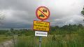
The entrance.
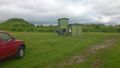
Shooters.
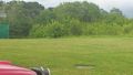
The small red piece of clay marks the approximate coordinates.


Achievements
Fasanen earned the Prize poultry Consolation Prize
|