Difference between revisions of "2012-03-29 50 11"
imported>Reinhard (report part 1) |
imported>FippeBot m (Location) |
||
| (4 intermediate revisions by 2 users not shown) | |||
| Line 3: | Line 3: | ||
| lon=11 | | lon=11 | ||
| date=2012-03-29 | | date=2012-03-29 | ||
| + | | retro=1 | ||
}} | }} | ||
| Line 15: | Line 16: | ||
== Retro Expedition on 2012-03-28 == | == Retro Expedition on 2012-03-28 == | ||
Reinhard had an other two-hour-WOP this Wednesday, but there was no hashpoint close enough to cycle there and back within two hours. On the other hand there was this inverse retro hash of the following day, on which no WOPs promised to occur, so now was the chance to get there and prove the coordinates can be reached. | Reinhard had an other two-hour-WOP this Wednesday, but there was no hashpoint close enough to cycle there and back within two hours. On the other hand there was this inverse retro hash of the following day, on which no WOPs promised to occur, so now was the chance to get there and prove the coordinates can be reached. | ||
| − | |||
| − | to be | + | Starting shortly after half past seven, the small village of Podelsatz, where Reinhard has been some years before, was reached easily in less than 40 minutes. Bearing in mind the satellite view, which as usual was much more flat than reality, Reinhard left the gravel path in a bend behind the village and started climbing a valley with trees and brushwood and a clue of something like an unused track. Dusk was proceeding quickly, while at some point Reinhard was already departing from the hashpoint. Time to make a left turn and start climbing (even more) the hillside. That part was easier than imagined and from the top it was just crossing an almost flat meadow and recognizing that the hash was some meters behind that meadow and an adjacent path within impenetrable brushwood (with sounds of fleeing wild animals). Reinhard was not going to crawl the remaining 5 m, especially since it wasn't the right date to do so and nobody would care at all. |
| + | |||
| + | It was dark by then and Reinhard hesitated with deciding which way to take back to Podelsatz. A topographic map including the small path he found near the hashpoint wasn't available. Taking the same way back would mean walking or carrying the bike down into the narrow valley and back to the village. So he started to check out some directions but none promised to become a wider and better path for cycling and even less they were leading back to Podelsatz. Reinhard reached the upper end of the valley, when he discovered an other path on the side opposite to the hashpoint and seeming to lead into the right direction. He also found stinky traces of horses and remembered to have seen a horse near the village so this had to be the silver bullet! Turned out the path really lead down at the hillside of the valley and with some effort Reinhard could even cycle there. Concentrating on not being thrown off the bike Reinhard ignored the (dark) display of his Garmin which would have shown him that he was somehow passing the village without getting back on the main road. When he finally was at the bottom nothing more than a one meter wide creek and an ascent was departing him from Podelsatz. So where did this f***ing (flowing) water come from? It would not have been absolutely impossible to jump over the creek at some narrow point after throwing the bike, but Reinhard couldn't be sure not to find other obstacles between the water and the next road so now he was caught in a trap - or to say it optimistic - in a dead end. After walking up and down the waterside for a while and watching the Window of OPportunity slowly but certainly closing, Reinhard had to come to a decision. He decided in favor of the safe and established way by partly cycling, partly walking his way back to the topmost spot and then walking down the valley where at some point he found that little bastard of a fountain and concentrated on definitely keeping on the right side of the creek this time. No wonder, he easily got back to the village and had to ask himself why he stupidly thought there could have been easier ways back from the hashpoint. Taking the quickest roads back to Jena, Reinhard reached home right before his WOP finally closed at half past nine. | ||
== Photos == | == Photos == | ||
| Line 24: | Line 26: | ||
|Image:20120329-50N11E-02.jpg|4.7 m this direction ... | |Image:20120329-50N11E-02.jpg|4.7 m this direction ... | ||
}} | }} | ||
| − | |||
[[Category:Expeditions with photos]] | [[Category:Expeditions with photos]] | ||
| − | |||
| − | |||
[[Category:Retro coordinates reached]] | [[Category:Retro coordinates reached]] | ||
| + | {{location|DE|TH|SHK}} | ||
Latest revision as of 03:14, 13 August 2019
| Thu 29 Mar 2012 in 50,11: 50.8794670, 11.7096261 geohashing.info google osm bing/os kml crox |
Location
In thicket, 5 m from a kind-of-path near Podelsatz, Thuringia.
Participants
Retro Expedition on 2012-03-28
Reinhard had an other two-hour-WOP this Wednesday, but there was no hashpoint close enough to cycle there and back within two hours. On the other hand there was this inverse retro hash of the following day, on which no WOPs promised to occur, so now was the chance to get there and prove the coordinates can be reached.
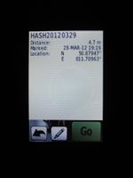
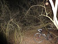
Starting shortly after half past seven, the small village of Podelsatz, where Reinhard has been some years before, was reached easily in less than 40 minutes. Bearing in mind the satellite view, which as usual was much more flat than reality, Reinhard left the gravel path in a bend behind the village and started climbing a valley with trees and brushwood and a clue of something like an unused track. Dusk was proceeding quickly, while at some point Reinhard was already departing from the hashpoint. Time to make a left turn and start climbing (even more) the hillside. That part was easier than imagined and from the top it was just crossing an almost flat meadow and recognizing that the hash was some meters behind that meadow and an adjacent path within impenetrable brushwood (with sounds of fleeing wild animals). Reinhard was not going to crawl the remaining 5 m, especially since it wasn't the right date to do so and nobody would care at all.
It was dark by then and Reinhard hesitated with deciding which way to take back to Podelsatz. A topographic map including the small path he found near the hashpoint wasn't available. Taking the same way back would mean walking or carrying the bike down into the narrow valley and back to the village. So he started to check out some directions but none promised to become a wider and better path for cycling and even less they were leading back to Podelsatz. Reinhard reached the upper end of the valley, when he discovered an other path on the side opposite to the hashpoint and seeming to lead into the right direction. He also found stinky traces of horses and remembered to have seen a horse near the village so this had to be the silver bullet! Turned out the path really lead down at the hillside of the valley and with some effort Reinhard could even cycle there. Concentrating on not being thrown off the bike Reinhard ignored the (dark) display of his Garmin which would have shown him that he was somehow passing the village without getting back on the main road. When he finally was at the bottom nothing more than a one meter wide creek and an ascent was departing him from Podelsatz. So where did this f***ing (flowing) water come from? It would not have been absolutely impossible to jump over the creek at some narrow point after throwing the bike, but Reinhard couldn't be sure not to find other obstacles between the water and the next road so now he was caught in a trap - or to say it optimistic - in a dead end. After walking up and down the waterside for a while and watching the Window of OPportunity slowly but certainly closing, Reinhard had to come to a decision. He decided in favor of the safe and established way by partly cycling, partly walking his way back to the topmost spot and then walking down the valley where at some point he found that little bastard of a fountain and concentrated on definitely keeping on the right side of the creek this time. No wonder, he easily got back to the village and had to ask himself why he stupidly thought there could have been easier ways back from the hashpoint. Taking the quickest roads back to Jena, Reinhard reached home right before his WOP finally closed at half past nine.
Photos
|

