Difference between revisions of "2012-05-15 52 4"
imported>Murfie (Created page with "{{subst:Expedition |lat = 52 |lon = 4 |date = 2012-05-15 }}") |
m |
||
| (20 intermediate revisions by 3 users not shown) | |||
| Line 1: | Line 1: | ||
| − | |||
| − | |||
| − | |||
| − | |||
| − | |||
{{meetup graticule | {{meetup graticule | ||
| lat=52 | | lat=52 | ||
| Line 10: | Line 5: | ||
}} | }} | ||
| − | + | ||
__NOTOC__ | __NOTOC__ | ||
== Location == | == Location == | ||
| − | + | Pan van Persijn, Katwijk | |
== Participants == | == Participants == | ||
| − | + | [[User:Murfie|Murfie]] | |
| − | |||
== Plans == | == Plans == | ||
| − | + | Go by car, park at the Panbos forest entrance, walk up north. | |
== Expedition == | == Expedition == | ||
<!-- how it all turned out. your narrative goes here. --> | <!-- how it all turned out. your narrative goes here. --> | ||
| + | Using satellite view, it turned out that this is in the middle of a dune near Katwijk. | ||
| + | The area where this spot is located looked fenced from the streets. However using the nearby | ||
| + | entrance to the forest, one would be able to walk up north, using small paths through the dunes. | ||
| + | |||
| + | When I arrived at the forest, it turned out to be not just a forest, but some kind of family attraction. | ||
| + | It is a recreational area which contains a forest, park, playground, etc. | ||
| + | Also, there's a restaurant where you can eat pancakes. | ||
| + | |||
| + | After I parked my car and walked into the forest for 20m, I was confronted with | ||
| + | a sign, telling I should buy a ticket from the machine to get access. | ||
| + | Normally you can just walk around the machine, as it is not blocking the entrance. | ||
| + | However, today the machine was broken, and there was a guy in a small cabin | ||
| + | next to it, selling entrance tickets. | ||
| + | |||
| + | So, I bought a ticket for 1,50 euro. | ||
| + | |||
| + | Then it was a 1,2km walk up to the north to reach the geohash. After a few 100 metres, I was able to | ||
| + | leave the forest and walk through the dunes. The narrow paths were clearly visible | ||
| + | on the satellite view, so I started following those. After 500m, I expected to | ||
| + | walk the path straight up to the geohash. However, there was a sign 'personnel only', entrance | ||
| + | prohibited. | ||
| + | So I decided to try to avoid this path by walking a large circle around it. This would be another | ||
| + | 1km walk. But after completing half the circle, the roads were blocked again. | ||
| + | |||
| + | Then I stepped over some barb wire to climb up a hill and try to reach the personnel path | ||
| + | anyway. However the bushes were to dense and I climbed back to the normal path. | ||
| + | Then I went back to the path where I found the first personnel only sign. There was | ||
| + | nobody around so I decided to go for it. After a few 100m though, there was a wooden fence | ||
| + | with a lock. I could climb over it, but the road ended there as well so then I had to manouevre myself through | ||
| + | some thick trees and bushes. I'm not Tarzan and it was getting late so I decided this one is unreachable and this is the | ||
| + | closest you could get. | ||
== Tracklog == | == Tracklog == | ||
| − | + | Not a real log but an approximation I drew by hand. | |
| + | Yellow line is just yellow because it's yellow. It could also be red. | ||
| + | <gallery perrow="5"> | ||
| + | |||
| + | File: 2012-05-15 52 4 track.jpg|Handdrawn tracking.. | ||
| + | </gallery> | ||
== Photos == | == Photos == | ||
| − | |||
| − | |||
| − | |||
<gallery perrow="5"> | <gallery perrow="5"> | ||
| + | File:2012-05-15_52_4_photo1.jpg|parking lot | ||
| + | File:2012-05-15_52_4_photo2.jpg|Reserved parking spot... | ||
| + | |||
| + | |||
| + | File:2012-05-15_52_4_photo3.jpg|map | ||
| + | File:2012-05-15_52_4_photo4.jpg|do not cross these animals | ||
| + | |||
| + | |||
| + | File:2012-05-15_52_4_photo5.jpg|silence | ||
| + | |||
| + | File:2012-05-15_52_4_photo6.jpg|The geohash should be out there somewhere | ||
| + | |||
| + | File:2012-05-15_52_4_photo7.jpg|The 'Pancake Farm' | ||
| + | File:2012-05-15_52_4_photo8.jpg|Entrance ticket | ||
| + | |||
</gallery> | </gallery> | ||
== Achievements == | == Achievements == | ||
| − | {{ | + | {{No trespassing |latitude=52 |longitude=4 |date=2012-05-15 |image= |name= [[User:Murfie|Murfie]]}} |
| − | + | {{Admit One geohash | |
| + | | latitude = 52 | ||
| + | | longitude = 4 | ||
| + | | date = 2012-05-15 | ||
| + | | name = Murfie | ||
| + | | price = EUR 1,50 | ||
| + | | venue = | ||
| + | | image = 2012-05-15_52_4_photo8.jpg | ||
| + | }} | ||
| − | + | {{#vardefine:ribbonwidth|800px}} | |
| − | |||
| − | |||
| − | |||
| − | |||
| − | |||
| − | |||
| − | |||
| − | |||
| − | |||
[[Category:Expeditions]] | [[Category:Expeditions]] | ||
| − | |||
| − | |||
| − | |||
| − | |||
| − | |||
| − | |||
| − | |||
| − | |||
| − | |||
| − | |||
| − | |||
[[Category:Coordinates not reached]] | [[Category:Coordinates not reached]] | ||
| − | + | [[Category:Not reached - No public access]] No trespassing signs :( | |
| − | + | {{location|NL|ZH}} | |
| − | [[Category:Not reached - No public access]] | ||
| − | |||
| − | |||
| − | |||
Latest revision as of 09:28, 16 March 2022
| Tue 15 May 2012 in 52,4: 52.1853632, 4.4111400 geohashing.info google osm bing/os kml crox |
Location
Pan van Persijn, Katwijk
Participants
Plans
Go by car, park at the Panbos forest entrance, walk up north.
Expedition
Using satellite view, it turned out that this is in the middle of a dune near Katwijk. The area where this spot is located looked fenced from the streets. However using the nearby entrance to the forest, one would be able to walk up north, using small paths through the dunes.
When I arrived at the forest, it turned out to be not just a forest, but some kind of family attraction. It is a recreational area which contains a forest, park, playground, etc. Also, there's a restaurant where you can eat pancakes.
After I parked my car and walked into the forest for 20m, I was confronted with a sign, telling I should buy a ticket from the machine to get access. Normally you can just walk around the machine, as it is not blocking the entrance. However, today the machine was broken, and there was a guy in a small cabin next to it, selling entrance tickets.
So, I bought a ticket for 1,50 euro.
Then it was a 1,2km walk up to the north to reach the geohash. After a few 100 metres, I was able to leave the forest and walk through the dunes. The narrow paths were clearly visible on the satellite view, so I started following those. After 500m, I expected to walk the path straight up to the geohash. However, there was a sign 'personnel only', entrance prohibited. So I decided to try to avoid this path by walking a large circle around it. This would be another 1km walk. But after completing half the circle, the roads were blocked again.
Then I stepped over some barb wire to climb up a hill and try to reach the personnel path anyway. However the bushes were to dense and I climbed back to the normal path. Then I went back to the path where I found the first personnel only sign. There was nobody around so I decided to go for it. After a few 100m though, there was a wooden fence with a lock. I could climb over it, but the road ended there as well so then I had to manouevre myself through some thick trees and bushes. I'm not Tarzan and it was getting late so I decided this one is unreachable and this is the closest you could get.
Tracklog
Not a real log but an approximation I drew by hand. Yellow line is just yellow because it's yellow. It could also be red.
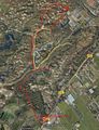
Handdrawn tracking..

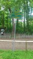
Photos
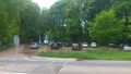
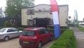
parking lot
Reserved parking spot...
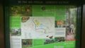
map
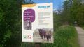
do not cross these animals
silence
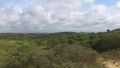
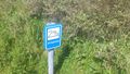
The geohash should be out there somewhere
The 'Pancake Farm'

Entrance ticket


Achievements
Murfie earned the No trespassing consolation prize
|
Murfie earned the Admit One Achievement
|
No trespassing signs :(