Difference between revisions of "2012-11-24 35 -79"
From Geohashing
imported>Birdray (Created page with "{{subst:Expedition |lat = 35) |lon = -79) |date = 2012-11-24 |image = }}") |
m |
||
| (3 intermediate revisions by 2 users not shown) | |||
| Line 1: | Line 1: | ||
| + | [[Image:{{{image|2012-11-24_35_-79b.jpg}}}|thumb|left]] | ||
| − | |||
| − | |||
| − | |||
| − | |||
| − | |||
| − | |||
| − | |||
| − | |||
| − | |||
{{meetup graticule | {{meetup graticule | ||
| − | | lat=35 | + | | lat=35 |
| − | | lon=-79 | + | | lon=-79 |
| date=2012-11-24 | | date=2012-11-24 | ||
}} | }} | ||
| − | |||
__NOTOC__ | __NOTOC__ | ||
== Location == | == Location == | ||
| − | + | On a private field in Liberty, NC. | |
== Participants == | == Participants == | ||
| − | + | [[User:Birdray|Birdray]] | |
| − | + | ||
| + | == Expedition == | ||
| + | I was on a road trip. On a whim, I opened the Geohashing app, and discovered that I was, at that moment, 4 miles away from the hashpoint in the [[Chapel_Hill,_North_Carolina|Chapel Hill]] graticule. I had two birds in the car with me, it had been a long day, and it looked like the hashpoint was on private property, but I couldn't pass that up. | ||
| − | + | Unfortunately, when I arrived, the hashpoint was indeed in the middle of someone's field, and the access point was their driveway. I'm a shy hasher and not up for the "Hi, I'm From The Internet" speech... not to mention while I was traveling with pets in the car. | |
| − | |||
| − | + | Hashpoint failed! But it was a scenic ten-minute detour from my route home. | |
| − | |||
| − | |||
| − | |||
== Photos == | == Photos == | ||
| − | + | ||
| − | |||
| − | |||
<gallery perrow="5"> | <gallery perrow="5"> | ||
| + | Image:2012-11-24_35_-79a.png | Me, sitting in my car, in the driveway, less than 400 feet from the hashpoint. SOCLOSE. | ||
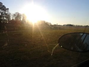
| + | Image:2012-11-24_35_-79b.jpg | Somewhere in this (blurry) field was the hashpoint. | ||
</gallery> | </gallery> | ||
== Achievements == | == Achievements == | ||
{{#vardefine:ribbonwidth|800px}} | {{#vardefine:ribbonwidth|800px}} | ||
| − | + | {{No trespassing | |
| + | | latitude = 35 | ||
| + | | longitude = -79 | ||
| + | | date = 2012-11-24 | ||
| + | | name = Birdray | ||
| + | | image = 2012-11-24_35_-79b.jpg | ||
| + | | distance = 388 ft | ||
| + | }} | ||
| + | {{Prize poultry | ||
| + | | latitude = 35 | ||
| + | | longitude = -79 | ||
| + | | date = 2012-11-24 | ||
| + | | name = Birdray | ||
| + | | reason = they were too shy to talk their way onto private property | ||
| + | | image = 2012-11-24_35_-79b.jpg | ||
| + | }} | ||
| − | |||
| − | |||
| − | |||
| − | |||
| − | |||
| − | |||
| − | |||
| − | |||
| − | |||
| − | |||
[[Category:Expeditions]] | [[Category:Expeditions]] | ||
| − | |||
| − | |||
| − | |||
| − | |||
| − | |||
| − | |||
| − | |||
| − | |||
| − | |||
| − | |||
| − | |||
[[Category:Coordinates not reached]] | [[Category:Coordinates not reached]] | ||
| − | |||
| − | |||
| − | |||
| − | |||
| − | |||
[[Category:Not reached - No public access]] | [[Category:Not reached - No public access]] | ||
| − | + | {{location|US|NC|RA}} | |
| − | |||
| − | |||
| − | |||
| − | |||
| − | |||
| − | |||
| − | |||
Latest revision as of 10:43, 22 September 2021
| Sat 24 Nov 2012 in 35,-79: 35.8821370, -79.5743111 geohashing.info google osm bing/os kml crox |
Location
On a private field in Liberty, NC.
Participants
Expedition
I was on a road trip. On a whim, I opened the Geohashing app, and discovered that I was, at that moment, 4 miles away from the hashpoint in the Chapel Hill graticule. I had two birds in the car with me, it had been a long day, and it looked like the hashpoint was on private property, but I couldn't pass that up.
Unfortunately, when I arrived, the hashpoint was indeed in the middle of someone's field, and the access point was their driveway. I'm a shy hasher and not up for the "Hi, I'm From The Internet" speech... not to mention while I was traveling with pets in the car.
Hashpoint failed! But it was a scenic ten-minute detour from my route home.
Photos
Achievements
Birdray earned the No trespassing consolation prize
|
Birdray earned the Prize poultry Consolation Prize
|


