Difference between revisions of "2013-03-26 43 -116"
From Geohashing
imported>Eldin |
imported>FippeBot m (Location) |
||
| (2 intermediate revisions by one other user not shown) | |||
| Line 11: | Line 11: | ||
== Participants == | == Participants == | ||
| − | [[User:Eldin|Eldin]] | + | [[User:Eldin | Eldin]] |
== Expedition == | == Expedition == | ||
| − | When I got off work a little early today, I decided to try for today's hash. From Google's satellite imagery, it looked to have a decent chance of being publicly accessible. I drove to a spot | + | When I got off work a little early today, I decided to try for today's hash. From Google's satellite imagery, it looked to have a decent chance of being publicly accessible. I drove to a spot a few miles from the hash, parked my car beside the 2 ruts that passed for a road, and started walking. However, I only made it about a quarter mile before my way was blocked by a locked gate and a no trespassing sign. I saw a lot of jackrabbits, ground squirrels, and other small furry creatures while I was walking, and it was overall a pleasant excursion. |
*Thwarted! No trespassing. -- [[User:Eldin|Eldin]] ([[User talk:Eldin|talk]]) [http://www.openstreetmap.org/?lat=43.33858245&lon=-116.04841485&zoom=16&layers=B000FTF @43.3386,-116.0484] 17:26, 26 March 2013 (MDT) | *Thwarted! No trespassing. -- [[User:Eldin|Eldin]] ([[User talk:Eldin|talk]]) [http://www.openstreetmap.org/?lat=43.33858245&lon=-116.04841485&zoom=16&layers=B000FTF @43.3386,-116.0484] 17:26, 26 March 2013 (MDT) | ||
| Line 31: | Line 31: | ||
| longitude = -116 | | longitude = -116 | ||
| date = 2013-03-26 | | date = 2013-03-26 | ||
| − | | name = [[User:Eldin|Eldin]] | + | | name = [[User:Eldin | Eldin]] |
}} | }} | ||
| Line 38: | Line 38: | ||
[[Category:Coordinates not reached]] | [[Category:Coordinates not reached]] | ||
[[Category:Not reached - No public access]] | [[Category:Not reached - No public access]] | ||
| + | {{location|US|ID|AA}} | ||
Latest revision as of 01:34, 14 August 2019
| Tue 26 Mar 2013 in 43,-116: 43.3601815, -116.0628796 geohashing.info google osm bing/os kml crox |
Location
In the desert southeast of Boise.
Participants
Expedition
When I got off work a little early today, I decided to try for today's hash. From Google's satellite imagery, it looked to have a decent chance of being publicly accessible. I drove to a spot a few miles from the hash, parked my car beside the 2 ruts that passed for a road, and started walking. However, I only made it about a quarter mile before my way was blocked by a locked gate and a no trespassing sign. I saw a lot of jackrabbits, ground squirrels, and other small furry creatures while I was walking, and it was overall a pleasant excursion.
- Thwarted! No trespassing. -- Eldin (talk) @43.3386,-116.0484 17:26, 26 March 2013 (MDT)
Photos
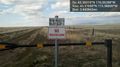
No Trespassing Sign @43.3769,-115.9880

Achievements
Eldin earned the No trespassing consolation prize
|