Difference between revisions of "2013-07-12 43 -116"
imported>Eldin (initial report) |
imported>FippeBot m (Location) |
||
| Line 29: | Line 29: | ||
[[Category:Not reached - No public access]] | [[Category:Not reached - No public access]] | ||
[[Category:Coordinates not reached]] | [[Category:Coordinates not reached]] | ||
| + | {{location|US|ID|AA}} | ||
Latest revision as of 03:06, 14 August 2019
| Fri 12 Jul 2013 in 43,-116: 43.5405488, -116.0434733 geohashing.info google osm bing/os kml crox |
Location
Near Hwy 21, close to Lucky Peak Reservoir.
Participants
Expedition
After I came home from work, I headed out to the hash. When I arrived near the coordinates, I discovered that what I had taken from the maps to be a public road was in fact a private driveway complete with a locked gate and a no trespassing sign. I drove a bit down a 1-lane dirt road towards another house which was near the hash point. I'm not completely certain that the hash wasn't on publicly accessible land, but there was a definite strip of private property between me and it. I knocked at the door of the house which was approachable without going through a locked gate, hoping to ask permission to cross their land to reach the hash. Alas, there was no answer, so I left without achieving my goal.
Photos
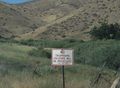
The sign beside the gate.
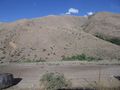
The hash is on that hillside, about 475ft away.


Achievements
Eldin earned the No trespassing consolation prize
|