Difference between revisions of "2013-07-30 -35 149"
imported>1PE (Created page with "{[subst:Expedition |lat = -35 |lon = 149 |date = 2013-07-30}}") |
m |
||
| (8 intermediate revisions by 2 users not shown) | |||
| Line 1: | Line 1: | ||
| − | { | + | |
| + | <!-- If you did not specify these parameters in the template, please substitute appropriate values for IMAGE, LAT, LON, and DATE (YYYY-MM-DD format) | ||
| + | |||
| + | [[Image:{{{image|IMAGE}}}|thumb|left]] | ||
| + | |||
| + | Remove this section if you don't want an image at the top (left) of your report. You should remove the "Image:" or "File:" | ||
| + | tag from your image file name, and replace the all upper-case word IMAGE in the above line. | ||
| + | |||
| + | And DON'T FORGET to add your expedition and the best photo you took to the gallery on the Main Page! We'd love to read your report, but that means we first have to discover it! :) | ||
| + | --> | ||
| + | {{meetup graticule | ||
| + | | lat=-35 | ||
| + | | lon=149 | ||
| + | | date=2013-07-30 | ||
| + | }} | ||
| + | |||
| + | <!-- edit as necessary --> | ||
| + | __NOTOC__ | ||
| + | == Location == | ||
| + | Outside the outer fence (just, to the East) of the Canberra gaol at Symonston, ACT. And, I am NOT going to be curious to find out whether the guards are interested in my story about GeoHashing! [[User:1PE|1PE (Canberra)]] ([[User talk:1PE|talk]]) 12:43, 29 July 2013 (EDT) | ||
| + | |||
| + | == Participants == | ||
| + | * [[User:1PE|1PE]] (my 50th claimed hash) | ||
| + | |||
| + | == Plans == | ||
| + | * [[User:1PE|1PE]] will drive along the Monaro Highway and stop at a convenient place, probably near the Southcare rescue helicopter base, to be able to get a picture along the back (eastern) fence of the gaol complex (the [http://en.wikipedia.org/wiki/Alexander_Maconochie_Centre Alexander Maconochie Centre (gaol)], Periodic Detention Centre and Symonston Temporary Remand Centre) and show the hash point. | ||
| + | |||
| + | == Expedition == | ||
| + | [[User:1PE|1PE]] drove along the Monaro Highway after my appointment to donate blood to the Red Cross. I went onto the side road at the gaol complex's entrance, and stopped at the end of the high fence at the creek bridge. I had determined that, if I lined up the end of this fence with the edge of the gaol fence, then the hash point was in line in the field beyond the gaol. The alignment of the fences is a neat trick called a "chinese transit". Great, that worked! Picture! | ||
| + | |||
| + | Various signs confirmed that the gaol authorities do not want anyone going near the fenced compound, so this was as close as I could go without raising the alarm. (They may still want to ask me why I went there, so here is proof that I may yet need.) | ||
| + | |||
| + | I am claiming the hash, as I went as close as the law allows, but acknowledge that I did not get there. | ||
| + | |||
| + | == Tracklog == | ||
| + | <!-- if your GPS device keeps a log, you may post a link here --> | ||
| + | |||
| + | == Photos == | ||
| + | <!-- Insert pictures between the gallery tags using the following format: | ||
| + | Image:2012-##-## ## ## Alpha.jpg | Witty Comment | ||
| + | --> | ||
| + | <gallery perrow="5"> | ||
| + | Image:2013-07-30_-35_149_14.07.46.jpg|The two fences line up, and there is the creek. | ||
| + | Image:2013-07-30_-35_149_14.08.34.jpg|No, thanks, I'll leave this to law enforcement. | ||
| + | </gallery> | ||
| + | |||
| + | == Achievements == | ||
| + | {{#vardefine:ribbonwidth|800px}} | ||
| + | <!-- Add any achievement ribbons you earned below, or remove this section --> | ||
| + | |||
| + | |||
| + | |||
| + | [[Category:Expeditions]] | ||
| + | |||
| + | [[Category:Expeditions with photos]] | ||
| + | |||
| + | <!--[[Category:Coordinates reached]]--> | ||
| + | |||
| + | [[Category:Coordinates not reached]] | ||
| + | [[Category:Not reached - No public access]] | ||
| + | {{location|AU|ACT}} | ||
Latest revision as of 09:36, 16 March 2022
| Tue 30 Jul 2013 in -35,149: -35.3730716, 149.1747862 geohashing.info google osm bing/os kml crox |
Location
Outside the outer fence (just, to the East) of the Canberra gaol at Symonston, ACT. And, I am NOT going to be curious to find out whether the guards are interested in my story about GeoHashing! 1PE (Canberra) (talk) 12:43, 29 July 2013 (EDT)
Participants
- 1PE (my 50th claimed hash)
Plans
- 1PE will drive along the Monaro Highway and stop at a convenient place, probably near the Southcare rescue helicopter base, to be able to get a picture along the back (eastern) fence of the gaol complex (the Alexander Maconochie Centre (gaol), Periodic Detention Centre and Symonston Temporary Remand Centre) and show the hash point.
Expedition
1PE drove along the Monaro Highway after my appointment to donate blood to the Red Cross. I went onto the side road at the gaol complex's entrance, and stopped at the end of the high fence at the creek bridge. I had determined that, if I lined up the end of this fence with the edge of the gaol fence, then the hash point was in line in the field beyond the gaol. The alignment of the fences is a neat trick called a "chinese transit". Great, that worked! Picture!
Various signs confirmed that the gaol authorities do not want anyone going near the fenced compound, so this was as close as I could go without raising the alarm. (They may still want to ask me why I went there, so here is proof that I may yet need.)
I am claiming the hash, as I went as close as the law allows, but acknowledge that I did not get there.
Tracklog
Photos
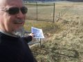
The two fences line up, and there is the creek.
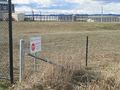
No, thanks, I'll leave this to law enforcement.

