Difference between revisions of "2013-08-30 45 -118"
From Geohashing
imported>Eldin (An expedition message sent via Geohash Droid for Android.) |
imported>FippeBot m (Location) |
||
| (3 intermediate revisions by one other user not shown) | |||
| Line 1: | Line 1: | ||
| − | |||
| − | |||
| − | |||
| − | |||
| − | |||
| − | |||
| − | |||
| − | |||
| − | |||
| − | |||
{{meetup graticule | {{meetup graticule | ||
| lat=45 | | lat=45 | ||
| Line 15: | Line 5: | ||
}} | }} | ||
| − | |||
__NOTOC__ | __NOTOC__ | ||
== Location == | == Location == | ||
| − | + | About a mile north of I-84 between La Grande and Pendleton | |
== Participants == | == Participants == | ||
| − | + | *[[User:Eldin|Eldin]] | |
| − | |||
== Plans == | == Plans == | ||
| − | + | To try to pick up this hash while traveling to Portland. | |
== Expedition == | == Expedition == | ||
| − | + | We got off the interstate a couple miles before the hash, and followed a road which ran more or less paralell to the interstate until we found a dirt road that headed in the direction of the hash. However, within a few hundred meters, we found fence and a sign indicating that the dirt road we were on entered the Umatilla Indian Reservation, and instructing us not to enter. Disappointed, we took a few pictures and turned batk. | |
| − | == | + | |
| − | + | *2nd hash of my Oregon trip, failed. Point was on indian lands. -- [[User:Eldin|Eldin]] ([[User talk:Eldin|talk]]) [http://www.openstreetmap.org/?lat=45.58180370&lon=-118.47444570&zoom=16&layers=B000FTF @45.5818,-118.4744] 17:17, 30 August 2013 (PDT) | |
== Photos == | == Photos == | ||
| − | |||
| − | |||
| − | |||
<gallery perrow="5"> | <gallery perrow="5"> | ||
| + | File:2013-08-30 45 -118 sign.jpg | Sign prohibiting access. | ||
| + | File:2013-08-30 45 -118 disappointment.jpg | Disappointed geohasher. | ||
</gallery> | </gallery> | ||
== Achievements == | == Achievements == | ||
{{#vardefine:ribbonwidth|800px}} | {{#vardefine:ribbonwidth|800px}} | ||
| − | + | {{No trespassing|date=2013-08-30|latitude=45|longitude=-118|name=[[User:Eldin|Eldin]]}} | |
| − | |||
| − | |||
| − | |||
| − | |||
| − | |||
| − | |||
| − | |||
| − | |||
| − | |||
| − | |||
[[Category:Expeditions]] | [[Category:Expeditions]] | ||
| − | |||
[[Category:Expeditions with photos]] | [[Category:Expeditions with photos]] | ||
| − | |||
| − | |||
| − | |||
| − | |||
| − | |||
| − | |||
| − | |||
| − | |||
| − | |||
[[Category:Coordinates not reached]] | [[Category:Coordinates not reached]] | ||
| − | |||
| − | |||
| − | |||
| − | |||
| − | |||
[[Category:Not reached - No public access]] | [[Category:Not reached - No public access]] | ||
| − | + | {{location|US|OR|UM}} | |
| − | |||
| − | |||
| − | |||
| − | |||
| − | |||
| − | |||
| − | |||
Latest revision as of 03:47, 14 August 2019
| Fri 30 Aug 2013 in 45,-118: 45.6001421, -118.4660292 geohashing.info google osm bing/os kml crox |
Location
About a mile north of I-84 between La Grande and Pendleton
Participants
Plans
To try to pick up this hash while traveling to Portland.
Expedition
We got off the interstate a couple miles before the hash, and followed a road which ran more or less paralell to the interstate until we found a dirt road that headed in the direction of the hash. However, within a few hundred meters, we found fence and a sign indicating that the dirt road we were on entered the Umatilla Indian Reservation, and instructing us not to enter. Disappointed, we took a few pictures and turned batk.
- 2nd hash of my Oregon trip, failed. Point was on indian lands. -- Eldin (talk) @45.5818,-118.4744 17:17, 30 August 2013 (PDT)
Photos
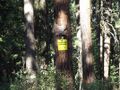
Sign prohibiting access.

Disappointed geohasher.


Achievements
Eldin earned the No trespassing consolation prize
|