Difference between revisions of "2014-01-01 37 -121"
imported>Codae (Created page with "{{subst:Expedition |lat = 37 |lon = -121 |date = 2014-01-01 }}") |
imported>FippeBot m (Location) |
||
| (3 intermediate revisions by 2 users not shown) | |||
| Line 15: | Line 15: | ||
}} | }} | ||
| − | + | ||
__NOTOC__ | __NOTOC__ | ||
== Location == | == Location == | ||
| − | + | In a field near US Highway 101, north of Gilroy, California. | |
== Participants == | == Participants == | ||
| − | + | * [[User:Codae|Codae]] | |
| − | |||
== Plans == | == Plans == | ||
| − | + | This one looked easy: drive to the road a hundred meters or so from the geohash, and then walk. I hoped that the creek in between would be a non-issue, since we've had an incredibly dry rainy season so far. If it did prove impassable, I could drive around to the other side of the field and walk across there--more walking, but all on dry, flat land. | |
== Expedition == | == Expedition == | ||
| − | + | I drove down to the area and got off the highway without issue, then headed for my projected parking spot via a road with the unlikely name of "No Name Uno". Already problems were apparent: the field smelled freshly manured (a contingency I hadn't planned for) and was full of green, trampleable seedlings (a contingency I had considered, but hadn't bothered to prepare for). I also found that what I'd taken to be a road from the satellite imagery was signposted "Private Drive: No Trespassing". By the time I got to the sign, though, there wasn't any space to turn around until I got to the corner where I was hoping to get to anyway, so I decided it was probably all right to drive on that stretch. | |
| + | |||
| + | As it turns out, the manure smell wasn't from the field, but from the animal hospital across the street from it, which meant that the field would be walkable if I could get permission from the owner. I asked a worker at the animal hospital where the owner might be: he didn't know, but did offer up that the hospital was closed, which I could have guessed. | ||
| + | |||
| + | I got back in the car and scouted around the edge of the field. I noticed that the creek was, conveniently, bone-dry, that an adjoining house had a smoking chimney, and that the side of the field with the geohash was, inconveniently, also cultivated. Then I entered a cul-de-sac to turn around and was greeted by the interesting sight of an emu paddock, for pictures of which I parked before continuing. | ||
| + | |||
| + | I went to the house with the fire and inquired of the elderly woman resident therein about the field's owner. Since she didn't know how to contact the man renting it or the couple owning it, I returned to the closest I could get to the geohash and took some more pictures. | ||
== Tracklog == | == Tracklog == | ||
| Line 34: | Line 39: | ||
== Photos == | == Photos == | ||
| − | + | ||
| − | |||
| − | |||
<gallery perrow="5"> | <gallery perrow="5"> | ||
| + | Image:2014-01-01 Street Sign.JPG | Este camino intencionalmente dejado en blanco. | ||
| + | Image:2014-01-01 Field.JPG | The geohash is out there somewhere (just beyond the white trees, if you can see them). | ||
| + | Image:2014-01-01 Emus.JPG | Emus. | ||
| + | Image:2014-01-01 Proof.JPG | As close as I got--within 100 meters. | ||
</gallery> | </gallery> | ||
== Achievements == | == Achievements == | ||
{{#vardefine:ribbonwidth|800px}} | {{#vardefine:ribbonwidth|800px}} | ||
| − | |||
| + | {{no trespassing|latitude=37|longitude=-121|date=2014-01-01}} | ||
| − | |||
| − | |||
| − | |||
| − | + | [[Category:Expeditions]] | |
| − | |||
| − | [[Category: | ||
| − | |||
| − | |||
| − | |||
| − | |||
[[Category:Expeditions with photos]] | [[Category:Expeditions with photos]] | ||
| − | |||
| − | |||
| − | |||
| − | |||
| − | |||
| − | |||
| − | |||
| − | |||
| − | |||
[[Category:Coordinates not reached]] | [[Category:Coordinates not reached]] | ||
| − | |||
| − | |||
| − | |||
| − | |||
| − | |||
[[Category:Not reached - No public access]] | [[Category:Not reached - No public access]] | ||
| − | + | {{location|US|CA|SL}} | |
| − | |||
| − | |||
| − | |||
| − | |||
| − | |||
| − | |||
| − | |||
Latest revision as of 05:04, 14 August 2019
| Wed 1 Jan 2014 in 37,-121: 37.0632903, -121.5807050 geohashing.info google osm bing/os kml crox |
Location
In a field near US Highway 101, north of Gilroy, California.
Participants
Plans
This one looked easy: drive to the road a hundred meters or so from the geohash, and then walk. I hoped that the creek in between would be a non-issue, since we've had an incredibly dry rainy season so far. If it did prove impassable, I could drive around to the other side of the field and walk across there--more walking, but all on dry, flat land.
Expedition
I drove down to the area and got off the highway without issue, then headed for my projected parking spot via a road with the unlikely name of "No Name Uno". Already problems were apparent: the field smelled freshly manured (a contingency I hadn't planned for) and was full of green, trampleable seedlings (a contingency I had considered, but hadn't bothered to prepare for). I also found that what I'd taken to be a road from the satellite imagery was signposted "Private Drive: No Trespassing". By the time I got to the sign, though, there wasn't any space to turn around until I got to the corner where I was hoping to get to anyway, so I decided it was probably all right to drive on that stretch.
As it turns out, the manure smell wasn't from the field, but from the animal hospital across the street from it, which meant that the field would be walkable if I could get permission from the owner. I asked a worker at the animal hospital where the owner might be: he didn't know, but did offer up that the hospital was closed, which I could have guessed.
I got back in the car and scouted around the edge of the field. I noticed that the creek was, conveniently, bone-dry, that an adjoining house had a smoking chimney, and that the side of the field with the geohash was, inconveniently, also cultivated. Then I entered a cul-de-sac to turn around and was greeted by the interesting sight of an emu paddock, for pictures of which I parked before continuing.
I went to the house with the fire and inquired of the elderly woman resident therein about the field's owner. Since she didn't know how to contact the man renting it or the couple owning it, I returned to the closest I could get to the geohash and took some more pictures.
Tracklog
Photos
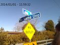
Este camino intencionalmente dejado en blanco.
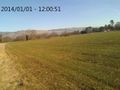
The geohash is out there somewhere (just beyond the white trees, if you can see them).
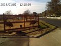
Emus.
As close as I got--within 100 meters.


Achievements
This user earned the No trespassing consolation prize
|