Difference between revisions of "2014-02-07 52 5"
From Geohashing
imported>JwB (Created page with " <!-- If you did not specify these parameters in the template, please substitute appropriate values for IMAGE, LAT, LON, and DATE (YYYY-MM-DD format) Image:{{{image|201402...") |
imported>FippeBot m (Location) |
||
| (17 intermediate revisions by 5 users not shown) | |||
| Line 1: | Line 1: | ||
| + | [[Image:{{{image|20140207 080808.jpg}}}|thumb|left]] | ||
| − | |||
| − | + | {{meetup graticule | |
| + | | lat=52 | ||
| + | | lon=5 | ||
| + | | date=2014-02-07 | ||
| + | }} | ||
| − | |||
| − | |||
== Location == | == Location == | ||
On a meadow between lelystad airport and the A6 motorway | On a meadow between lelystad airport and the A6 motorway | ||
== Participants == | == Participants == | ||
| − | [[User:JwB|JwB]] | + | [[User:JwB|JwB]] |
| − | |||
| − | |||
| − | |||
== Expedition == | == Expedition == | ||
| Line 22: | Line 21: | ||
== Photos == | == Photos == | ||
<gallery perrow="5"> | <gallery perrow="5"> | ||
| − | Image:20140207 080808 | + | Image:20140207 080808.jpg| Gate |
</gallery> | </gallery> | ||
| Line 31: | Line 30: | ||
| latitude = 52 | | latitude = 52 | ||
| longitude = 5 | | longitude = 5 | ||
| − | | date = | + | | date = 2014-02-07 |
| name = JwB | | name = JwB | ||
| − | | image = 20140207 080808 | + | | image = 20140207 080808.jpg |
| distance = 454 m | | distance = 454 m | ||
}} | }} | ||
| − | + | [[Category:Expeditions]] | |
| − | + | [[Category:Expeditions with photos]] | |
| − | [[Category: | ||
| − | + | [[Category:Coordinates not reached]] | |
| − | |||
| − | [[Category: | ||
| − | |||
| − | |||
| − | |||
| − | |||
| − | |||
| − | |||
| − | |||
| − | |||
[[Category:Not reached - No public access]] | [[Category:Not reached - No public access]] | ||
| + | {{location|NL|FL}} | ||
Latest revision as of 05:27, 14 August 2019

| Fri 7 Feb 2014 in 52,5: 52.4571314, 5.4735875 geohashing.info google osm bing/os kml crox |
Location
On a meadow between lelystad airport and the A6 motorway
Participants
Expedition
this one is near the road to work. Google maps already showed that it is on some farm-land. Decided to check whether it was open or not. A small ditch separates the land from the public road. When close to the hash (~450m) there is a dam gated with a fence, picture below.
Photos
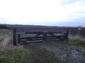
Gate
Achievements
JwB earned the No trespassing consolation prize
|